54 below
zero, Seneca is Oregon's Icebox
contact: jupiterman47@gmail.com
Your
evening news was full of news 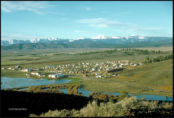 about Seneca on January 26, 2016!
54 Below Zero on February 10, 1933; the coldest
ever recorded in the State of Oregon! Here is Seneca, perched
4,700 ft. high in its remote mountain valley north of
Burns and south of John Day, with Hwy 395 running through its
center. These days, it has only 220 citizens, and seemed forgotten
by the rest of Oregon until late January of 2016. That was when
a dramatic arrest took place south of town on the highway just
south of the Joaquin Miller Wayside/horse camp (see picture and
facts about wayside here). Ammon Bundy
and several of his key people encountered a massive State Police/FBI
roadblock on the evening of January 26th. At that point in time,
Ammon's armed takeover of the nearby Malheur Wildlife Refuge had
been going on for 24 days. It was a self-styled heavily-armed
revolt against the Federal government, staged by people almost
entirely from outside the State of Oregon. The arrest was marred
by the fatal shooting of Lavoy
Finicum, who had sped
off and attempted to run the police blockade. Ultimately, the
occupation lasted 41 days, ending on Feb. 11th, when the remaining
four occupiers of the Refuge surrendered to the authorities. (Ammon,
son of Cliven Bundy)..... Finally Seneca could relax
and go back to business as usual in its high mountain valley.
Many decades
previous, back in Seneca's glory days, the little city was a company-owned
lumber boom town that was linked by railroad to Burns, where the
Hines lumber empire of Chicago made its Oregon Base of operations;
the prize was the virgin pine forests of the region, especially
the magnificent stands of Ponderosa pine around Seneca. The still-isolated
little hamlet is routinely Oregon's coldest place, although 99%
of Oregonians will NEVER KNOW IT, as its weather news and data
are NEVER picked up by the media----- In 1933, a couple of years
after the establishment of its official weather station in mid-1931,
it recorded 54 degrees below zero during a "Siberian Express"
cold wave that set State all-time record low-temperatures that
still stand in the Year 2010 as far away as Texas! (see bottom of page for the
actual worldwide records of February, 1933)....IIf you are interested in ordering
the newspaper story, please click here..... Maybe 1933 will not seem so far away in its
historical context: Franklin D. Roosevelt became President of
the United States; Adolf Hitler was beginning his rise to power
in Germany; and US banks were in an absolute panic over the deepening
Great Depression, most of them CLOSED in February while Oregon's
temperature record was being set! . In the
image above, Spring flooding due to heavy snow melt in the higher
moutains makes the village appear abnormally wet. Generally, it
has a very cold and dry climate, a lot like Tibet, actually. The
Strawberry Mountains rise to 9,000 feet in background. The Logan
Valley is about 15 miles to the east, higher, and possibly even
colder than Seneca... And, there is a place colder even than Seneca,
but it is uninhabited-- it's a small 5,500 ft. valley named Crane Prarie, ten miles east of Logan Valley...
It's remote weather station verifies that it is definitely colder
than Seneca, at least during periods of stagnating air that typically
produce Oregon's record cold nights. (see link to new webpage
on this topic just above). While mentioning the topic of places
even colder than Seneca, I will mention that Seneca's 54 below
was unofficially beaten in 1962 (click for more).
Seneca is quite
capable of generating a week-long string of 40 below zero nights
in any sizeable Arctic cold snap; the last time it did so was
in 1989 (the year the Exxon Valdez oil tanker ran aground in Alaska).
Officially, Seneca has been down to 54 below zero F; unofficial
Old Timer reports from before the establishment of the official
weather station recorded 60 below zero in the Big Cold Snap of
1927, and 1924 is also mentioned as a year where it likely was
lower than 55 below, and one wonders also about early December
1919, when many records were set that still stand today, eg. Yakima,
WA at 24 below on Dec. 13th........Back in 1931 Seneca came onto
the weather reporting stage with a bang, and soon was setting
State records left and right, eg. during the very nasty winter
of 1931-32, where the lonely town was hit with what appear to
be four sucessive arctic air invasions... seeing 30 below Nov.
29, more serious cold Dec. 15 where it went to 38 below, then
worse yet January 23 at 41 below, and finally a late winter smash
perhaps still not equalled in Oregon history, a 49 below on February
14, 1932..... Due to Seneca's known potential to set a new State
temperature record even colder than 54 below, the Weather Service
in 1995 installed a special type of arctic thermometer at Seneca,
capable of reading directly to 60 below zero without error (but
will "Global Warming" make this pointless, see bottom of this page).
Link to Oregon
Climate Service's new webpage commemorating Seneca's records, by George Taylor,
State Climatologist, with abundant quotations from my original
interviews with Seneca residents, plus historical material. And,
Click
here to see Seneca's weather station and then meet Howard Lohf, the Seneca Cooperative Weather
Observer who painfully measured his record-breaking thermometer
with a ruler that morning in 1933-- it had been so cold that the
mercury had gone completely off the scale of at 40 below zero!
Play
amateur weatherman!
How cold is it
in Seneca right now? Click
here to enter a National Weather Service (NWS) site that will tell you both the most
recent hourly temp at Seneca, and also the previous seven days
hourly temperatures.... On the NWS site, you will see an interactive
complex map of Eastern Oregon-Eastern Washington. The trick of
the map is that only the most major towns are named, so you will
need to hover your mouse over the tiny crosses that have temperatures
next to them, eg. "30" showing 30 degrees F --- To find
Seneca, hover on the crosses south of John Day, and soon you'll
see the one showing a box of information about Seneca. Smile,
now you're a real Oregon weather nut!
This photographer
wrote a story for Cascades East Magazine (Winter 94-95 edition)
about Seneca's friendly, cold-hardened residents, please visit
the Howard Lohf link provided: Howard
Lohf. You'll also
see the current Seneca weather station and meet the Cooperative
Weather Observer Mr.
Saunders.
"ARCTIC OREGON" -- Speaking of extreme
Cold in Oregon, SEVEN other populated spots in Oregon have recorded
50 below zero or worse, two of the most well-known being Meacham just
off I-84 in the Blue Mountains, (click link)---- and Ukiah, just
north of the John Day region in north-central Eastern Oregon...
I have reworked a 1930
weather station map
to show their locations, click
here... I call them
simply: "Oregon's Arctic Kings." For a listing of what
I call Oregon's "Arctic Queens," click here.
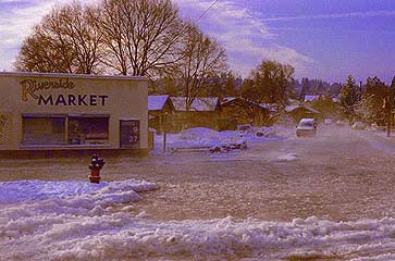
Also, even major
cities east of the Cascade Range such as Bend
can experience ice jam flooding, such as occurs in really arctic
places like Alaska. Here the Deschutes River at Mirror Pond in
Bend has ice-jammed and shown the owners of the Riverside Market
how accurate they were in naming their business! This was probably
the big arctic cold wave of Christmas-time 1983. The gas price
on the side of the market reads $1.29, amazing!
World's Record
Cold
Speaking of colder
yet, take a peek at current conditions at the World's Acknowleged
Record Holder, Vostok, Antarctica. Hint: remember that the seasons
are reversed if it doesn't seem terribly cold right now-----At
over 11,000 ft. on the Antarctic Plateau, Vostok Station holds
the World's All-Time record, a stunning 129 degrees below zero
F. (July 21, 1983) ...even in mid-summer, it rarely rises above
minus 40 degrees! Please click
here and you will
see Vostok weather for the past several days. On April 19, 2005
it was 87 below zero when I checked, the equivalent of mid-October
in the U.S.
February,
1933 was a world-record setting Arctic Express cold wave, with
records still standing in 2006! A true "Siberian Express."
February 6th,
1933, 90 below zero, still the coldest it has ever
been in the Northern Hemisphere!...Located in the heart of Siberia,
the village of Oymyakon in Russia is widely considered to be the
coldest inhabited place on Earth. A temperature of -90 °F
(-67.7 °C) was recorded there back in 1933 — the lowest
recorded temperature for any permanently inhabited spot in the
world.
February 7th,
1933, 12 below zero, Salt Lake City, Utah, still the
coldest it has ever been on that date.
February 8th,
1933, 23 below zero, Seminole, Texas, still the coldest
it has ever been in Texas!
February 9th,
1933, 30 below zero, Salt Lake City, Utah, still the
coldest it has ever been in Salt Lake City!
February 9th,
1933, 17 below zero, Spokane, Washington, still the
coldest ever seen for a Feb. 9th!
February 9th,
1933, 63 below zero, Moran, Wyoming, still the coldest
it has ever been in Wyoming!
February 9th,
1933, 66 below zero, West Yellowstone, Montana, still
the coldest January temperature ever recorded in Montana!
February 9th,
1933, 54 below zero, Ukiah, Oregon, tied for the coldest
it has ever been in Oregon!
February 10th, 1933, 54 below zero in Seneca, officially cited as Oregon's
coldest due to Weather Service policy of citing the most recent
occurrence of a temperature record..... Meanwhile, in the sheltered
Willamette Valley, here's how Feb. 9 and 10 went: Eugene: 11 degrees
above zero on Feb. 9, 1933, and 15 degrees on Feb. 10, 1933 (both
records still standing). Salem: 13 degrees on Feb. 9, 1933, and
12 degrees on Feb. 10, 1933 (both records still standing, and
Salem's records go all the way back to 1893!).... Portland: 1933
temps. unknown, the Weather Service cites records only back to
1940 for Portland, and those records give us Feb. 9 and 10 this
way: a puny 25 degree record low for the 9th (in 1986), and 22
degrees for the 10th (in 1982).
1933, Crater Lake National Park, 6,400
ft, Oregon Cascades, with notes about La Nina vs. El Nino
1933 did not
produce any long-standing extreme cold records at Crater Lake
National Park on the crest of the Cascades, some 180 air miles
to the southwest of Seneca. However, two Oregon extreme snowfall
records were set during the winter of 1932-1933 at Crater Lake.
The first --- a monumental 879 inches of snow for the winter season
(seventy-three feet of snow, as high as an nine-story building).
The second---Oregon's monthly State snowfall record of 256 inches,
set during January, 1933. This was just weeks before Seneca was
hit with stunning 54 degree below zero temperatures.... Oregon has not seen a winter to
compare in the seventy years since then! .... Discussion:
El Nino vs. La Nina:
Modern science informs us that it is very likely that a strong
La Nina was behind 1933's conjunction of severe cold and big snow-making
storms in the mountains. To quote from State Climatologist George
Taylor "...Extreme cold events occur almost exclusively during
La Nina years." In correspondence with him, he stated, "1932-33
was an El Nino turning into a La Nina, much like this year (2007),
though it happened in 1932 later in the year. Often those transition
years produce the most extreme events."
Other
Arctic Kings, Queens, Princes, and Princesses
Other spots in
Oregon that have been minus 50 or below include: Ukiah, Danner,
Blitzen, Drewsey, and Riverside (Blitzen now barely even a ghost
town, and Riverside's status seems now more like a ranching operation
rather than a town since its Post Office closed down)... Also
big in the 50-Below Club are Austin and Meacham.
All occasions at these seven locations were pre-1940... There
is a strong possibility that the extreme winters of both 1949
and 1950 might have brought minus 50 to Seneca, but there were
no weather observations made in either of those winters. There
may be more recent 50-below dates from other stations, even other
Arctic King places to add to the list, but some of the promising
stations had "missing data" in their records during
years when they might have recorded extreme cold.. .. One in particular
that comes to mind is "Fox," in a 4,400 ft. high valley,
about 30 miles north of John Day-- it recorded 42 below zero on
January 31, 1950, but had no data for 1949, and actually only
recorded data until about March of 1957, ending with an impressive
34 below on Jan. 26, 1957........Back to the cold wave of 1950---Given
42 below zero cold in the general vicinity of Seneca in January
1950, my personal bet is that late January, 1950 was the last
time that Oregon saw minus 50 or lower-- and my bet is that it
occurred in Seneca... however,
I should also mention at this point that there is unofficial data
that January
of 1962 saw
temperatures go lower than Seneca's 54 below! (click
for more)
1933--- a really
record-setting year for Oregon... As if setting Oregon's all-time
record low weren't enough, Oregon's worst-ever wildfire ignited
on August 14th, 1933, the infamous Tillamook Burn..... Related
Climatic Note: Oregon experienced a record-setting drought during
most of the 1930s, which some claim was equalled only by the terrible
drought
of the 1840s. The
generalized effect of years of drought probably set the stage
for the severity of the Tillamook Burn. The dryness may also have
have been an underlying factor in the winters of 1932, 1933, and
1937, which all set numerous all-time cold records still not equalled,
eg. Austin having, in January 1937, an Average temperature for
the entire month of an even 0.0 degrees F. (this is really cold,
4 degrees colder than the January average in Fargo, North
Dakota)... Austin is a tiny place in a high mountain valley east
of John Day and Prarie City.
Climate Change
Notes comparing the 1930s to Recent Times---- the existence of global warming has been endlessly
argued, and the following data will help illustrate how confusing
things can be. The 1930s in Oregon established Oregon's all-time
record low and also many other winter cold records that still
stand--- so one is surprised to learn that the hottest-ever summer
in U.S. history occurred in 1936, with an average summer temperature
(June 1-Aug. 30) of 74.73 degrees F (period of record 1895-2005)........
The Nation's third hottest summer was 1934.. Astoundingly, 1933
nationwide was the sixth hottest summer ever recorded (73.59 degrees
F)!... As a matter of fact, 5 out of the 10 hottest summers ever
recorded in the U.S. occurred during the 1930s! Meanwhile, only
4 out of the 10 hottest-ever summers have occurred since 1990.
Thus, during the 1930s, U.S. weather experts might have been convinced
that Global Warming was taking over, but, if they had lived in
Oregon, they might have been drawing an opposite conclusion!
No
More Record-Setting Cold and Snowy Winters? Some thoughts on Global
Warming Theories vs. the Coming new Ice Age.
Why
haven't there been any extreme cold winters in recent years (eg.
the last really extreme arctic air Cold Wave in Seneca was over
20 years ago, 48 below zero in 1989)? Portland's last year with
anything one might call a "real" snowstorm was probably
10 years ago, in 1993. (click for page with Deep Portland Snowfalls)
----Note: as of early January 2009, Portland has now
racked-up a very impressive snowfall record, the winter so far
becoming the third snowiest by some measures, coming in well behind
the huge winters of 1949-50, and 1968-69 (note, also, that the
severe cold that accompanied those other two winters has been
lacking, and the coldest temperature of the period was 20 degrees,
recorded on three occasions shortly before Christmas).
Are extremely
cold winters a thing of the past-- with Global Warming being the
culprit? Below is a quotation from the NCDC (National Climatic
Data Center), which was used in George Taylor's book, "The
Climate of Oregon" (1999).
The 1999 quote
states that NCDC researchers have not found clear evidence for
global warming, but there is a noteworthy trend: "... There has been a clear trend
in recent decades, however, to fewer extremely low minimum temperatures
in several widely-scattered areas..." A similar trend has been posited by George
R. Miller in his new book, "Pacific Northwest Weather, But
My Barometer Says Fair!" (Frank Amato Publications, 2002).
Mr. Miller notes a major reduction in winter snowfall in both
Portland and Seattle since records began in approx. 1870, eg.
ten year periods in the early portion showing over FOUR times
as much snowfall as recent ten year periods! (winters 1880/81-1889/90
had 196 inches of snow, whereas winters 1980/81-1989/90 had a
paltry 40 inches).... Click
for more thoughts on Global Warming as it might be affecting Oregon.
The upshot for
children and cold-loving adults in Oregon is depressing, predicting
that the current spate of boring winters will continue, with little
or no snow, no exciting cold snaps, and in fact whole winters
where it only drops below 28 degress F a few times. Those with
really long memories can wonder if ever again will the Willamette
River at Portland freeze over so that autos can cross on the thick
ice-- the last time that occurred was over fifty years ago! Here
are some quotations from the Oregonian newspaper in December of
1924, when both the Willamette and Columbia Rivers were frozen
solid, and even as far south as Eugene, the ice was still seven
inches thick; the great freeze-up began by mid-month and extended
well into January:
"....Sunrise
on the Columbia* between Portland and Astoria presents a wonderful
sight, according to those who came on the early train from Astoria.
The river is frozen and in billows, reflecting the color of the
sunrise, as do the frozen waterfalls along the way." ..(*The
mighty Columbia River is 1,240 miles long, and ranks as one of
the United State's largest rivers). For a better sense of just
how cold Oregon got in December 1924, click here to see what happened in far southeastern
Oregon at the hamlet of Riverside!
Some climate
researchers believe that we are living in the tail end of an Interglacial
period; in fact, that the next major glacial period is overdue.
Some believe that whatever global warming effects man's technology
has had, it is only slightly delaying or mitigating the great
cold and ice to come, when the entire northern half of North America
is once again going to become uninhabitable under the unstoppable
power of glaciers thousands of feet thick. Goodbye, New York,
Boston, Chicago, perhaps even Washington, D.C..(link to my pages
about Ice
Age Floods and Ice Age Climate in the Portland area)........ Let's finish this section
with notes from two winters, 1950 and 1968-69... First, some quotations
from the brutal winter of 1950, where for an entire month the
Portland area lay under a deep blanket of snow over a foot deep:
"Temeratures
over the entire State were far below normal, and precipitation
was much above. The major portion of this precipitation fell in
the form of snow and sleet even in the western division (eg. Willamette
Valley). In Portland a total of 32.9 inches of snow fell during
the month....Severe blizzard conditions on the 13th and a heavy
sleet and ice storm on the 18th-19th together caused several hundred
thousand dollars worth of damage and virtually halted traffic
for two or three days over widespread areas, particularly in western
Oregon...." George Taylor adds, "...All highways west
of the Cascades and through the Columbia River Gorge were closed
due to large snow drifts." (First quote is from the 1950
Annual Climatological Summary, written by E.S. Ellison, and second
quotation is from The Oregon Weather Book by George Taylor.
) Click
here for more on Winter 1950.
Finally, bringing
us to a more recent time, let's not forget the winter of 1968-69.
This winter featured a brutal double-whammy of snow in January.
In total there were 18 days with one inch or more of snow on the
ground, with snow up to 9 inches deep during the first period,
and up to 10 inches deep in the second! Kids were in heaven and
snowmen almost out-numbered people by the time the long snowy
period ended.
More
Recent Seneca Cold Events and Records
Seneca
Warming Up in the New Millenium, 2000-present, and notes about
insane diurnal changes in Oregon
OREGON
in the New Millenium, 1989-Present, things really warming up!
The
Future of Snow Sports in Oregon if Global Warming is True
Page last reviewed 11/20/2025
****************************************************************************************
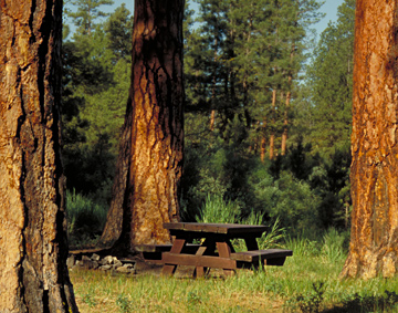
I camped once at the peaceful
little Joaquin Miller wayside area south of Seneca. Here's a picture
from that time, back in the mid-90s.
Parallels between
Lavoy Finicum and Joaquin Miller? Miller
is listed in the Oregon Blue Book as a "Notable Person"
--Miller was born in 1837 in Indiana of Quaker parents. In 1852
Joaquin and his parents made the dangerous overland wagon trip
to Oregon, settling near Eugene. By about 1854, he was in California
gold mining. Here the Blue Book notes, "He later survived
other battles with northern California Indian groups, and had
several altercations with the law over matters relating to the
ownership of livestock and gun play." This gun-totin' phase
of Miller's life apparently over, he returned to Eugene and studied
Law, becoming an attorney in 1861 and soon a newspaper editor:
"In his newspaper, The Eugene City Democratic Register,
he pleaded for an end to the Civil War, adopting the Quaker creed
of his father." But this city existence did not last. The
Blue Book reports: "In 1864 he drove a herd of cattle across
the Cascade Mountains to Canyon City where he planted the region's
first orchard and served as Grant County Judge until 1870."
His time in Eastern Oregon is probably a main reason that Joaquin
Miller Wayside was named for him.... But the talented man did
not stay in the remote reaches of the West. I will quote again
from the Oregon Blue Book: "Miller's work Songs of the
Sierras was published in Great Britain during a visit in 1870-1871.
He returned to the United States to great acclaim for his writing
and lived in San Francisco for a time before traveling in Europe
and Asia from 1873 to 1880. He resided in New York and Washington
D.C. until moving to Oakland, California where he lived from 1885
to 1897. Oakland remained his home intermittently until his death
in 1913. Miller's colorful life included stints serving as a newspaper
correspondent during the Klondike Gold Rush in 1897-1898 as well
as the Boxer War in China in 1899."
"Among his other works of poetry
and prose were My Life Among the Modocs, Unwritten History,
In Classic Shades, and A Royal Highway of the World."
75