More
on Seneca and the Future of Oregon's Arctic King
SENECA
IN THE NEW MILLENIUM, AND A LOOK BACK AT PAST NOTABLE COLD WAVES
Seneca,
Oregon
Although Seneca's
former mighty Arctic cold waves may have been toned-down by global
warming (see bottom of previous page), Seneca in the mid-1990s and into the
2000s was still capable of generating some extreme minimums that
would cause old records to fall in any of the major U.S. cities
(outside Alaska). For the most recent cold waves, eg. 2011 and
2013, click
here.
Oregon's most
recent major arctic cold wave was in 1990. Although 1996 saw a
respectable arctic blast, it was only a moderate cold wave by
old-time Seneca standards--- the '96 cold wave hit in very late
January of 1996. In Seneca it generated a respectable 35 below
zero on the coldest night....But by old-time Seneca standards,
this was only a moderate cold wave,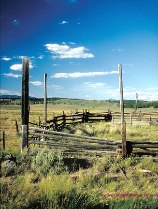 which set no new records on any of its five days... Here are the
figures for the 1996 cold wave: January 30, low temperature was
8 below zero... January 31, low was 19 below zero... February
1, low was 20 below zero... February 2, 1996, the low was 35 below zero... February 3, low was
32 below zero... February 4-- the cold wave abruptly broke...(click
here to
see some examples of really major cold waves in Seneca!).....
Image: old corral a few miles north of Seneca. This is
the northern part of the Bear Valley, elevation about 4,800 feet.
In the middle distance is a deserted homestead, and on the horizon
is 9,000 foot high Strawberry Mountain. See page bottom for an
enlargement of the deserted homestead.
which set no new records on any of its five days... Here are the
figures for the 1996 cold wave: January 30, low temperature was
8 below zero... January 31, low was 19 below zero... February
1, low was 20 below zero... February 2, 1996, the low was 35 below zero... February 3, low was
32 below zero... February 4-- the cold wave abruptly broke...(click
here to
see some examples of really major cold waves in Seneca!).....
Image: old corral a few miles north of Seneca. This is
the northern part of the Bear Valley, elevation about 4,800 feet.
In the middle distance is a deserted homestead, and on the horizon
is 9,000 foot high Strawberry Mountain. See page bottom for an
enlargement of the deserted homestead.
THE NEW
MILLENIUM APPEARED TO BE WARMING UP, BUT THEN IN 2010, 2011 AND
2013, THERE WAS CAUSE FOR HOPE!
UPDATES, January
2014: In the many years since 1990, Seneca had been a wimper of
its former Arctic King self. But late in 2010 and early in 2011,
there was some cause for hope. And then again in Dec. of 2013....
Read on..... The
year's low for 2009 was a pathetic 1 below zero. But in late December
of 2010, the first really significant arctic blast since 1996
descended on Seneca. It was fairly mild compared to the mighty
cold waves of the past (click to see some of them).... The
arctic air of 2010 hit rather suddenly on Dec. 31, with the temperature
plummeting to 27 below zero. The cold wave was six days long,
again nothing compared to the long-lasting severe cold of the
big Arctic blasts, but still, for six days it was subzero every
night. The coldest was 30 below on January 1, 2011. The other
four nights were never worse than 16 below....But then to cap
off the Winter of 2012-2011, on Feb. 26, 2011, Seneca reared up its Arctic head
quite unexpectedly, hitting 33 below zero on Feb. 26th; it was a real oddball
event, eg. the 25th was a little cold but hardly more than a bit
sub-normal, then whamo, 33 below on the 26th, then the next night
was well above zero and it was all over, like a dream! ...............................
Note: the 1996 cold wave had hit in very late January of 1996.
In Seneca it generated a respectable 35 below zero on the coldest
night....But by old-time Seneca standards, this was only a moderate
cold wave, neither very deep or very long. It set no new records
on any of its five days... Here are the figures for the 1996 cold
wave: January 30, low temperature was 8 below zero... January
31, low was 19 below zero... February 1, low was 20 below zero...
February 2,,
1996, low was 35 below zero... February 3, low was 32 below zero... February
4-- the cold wave abruptly broke...(click here to see some examples
of truly major cold waves in Seneca!).....
December of 2013 featured an early December
arctic blast that very much reminded me of the huge blast that
hit all of Oregon in early December of 1972. (click to read about 1972). The 2013
blast was not as severe or as long-lasting, but it did get down
to 26 below on one night (December 8th).... What made this a truly
significant Arctic blast was not Seneca's 26 below; contrary to
normal patterns, Seneca was far from the coldest spot in the State.
That distinction was
41 below zero,
and it went to a very new unmanned remote station up on the High
Desert east of Bend named Horse Ridge (see picture). 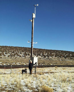 It
sits in a former Pleistocene lake bed just west of Pine Mountain.
It's definitely cold sink topography. Horse Ridge may prove to
be a rival in the Arctic
King category
with Seneca, although Seneca is a real town with permanent residents.....
The Dec. 2013 cold wave was quite peculiar, because it seemed
to really focus itself on just a few areas, mostly notably Central
Oregon, parts of Eastern Oregon, and very peculiarly, Eugene in
the Southern Willamette Valley! Here are some figures and records
set: Redmond at 27 below zero. Lakeview setting a new all-time
low of 27 below. Burns at 30 below zero. Medford at 2 degrees.
Eugene was amazing: it was first buried with 7 inches of nice,
dry snow on Dec. 6th, and then the temperature plummeted to 10
below on Dec. 8th, just two degrees shy of Eugene's all-time record
since 1890... and the cold wave settled in and lingered for nine
full days..... For contrast, the coldest Seattle got was 19 degrees
and the coldest in Portland was 12 degrees.
It
sits in a former Pleistocene lake bed just west of Pine Mountain.
It's definitely cold sink topography. Horse Ridge may prove to
be a rival in the Arctic
King category
with Seneca, although Seneca is a real town with permanent residents.....
The Dec. 2013 cold wave was quite peculiar, because it seemed
to really focus itself on just a few areas, mostly notably Central
Oregon, parts of Eastern Oregon, and very peculiarly, Eugene in
the Southern Willamette Valley! Here are some figures and records
set: Redmond at 27 below zero. Lakeview setting a new all-time
low of 27 below. Burns at 30 below zero. Medford at 2 degrees.
Eugene was amazing: it was first buried with 7 inches of nice,
dry snow on Dec. 6th, and then the temperature plummeted to 10
below on Dec. 8th, just two degrees shy of Eugene's all-time record
since 1890... and the cold wave settled in and lingered for nine
full days..... For contrast, the coldest Seattle got was 19 degrees
and the coldest in Portland was 12 degrees.
***********************************************************************************************************************************
Click here to
skip
to a listing of
the major cold waves to hit Seneca since the Big One of 1933!
 Early
Season Cold-- one truly remarkable thing about cold in Seneca
is how early in the season it can occur, and this facet of Seneca's
climate doesn't appear to have warmed up in recent years, eg.
in Fall of 2002 a major cold spell began on October 12, and continued
through the end of the month.... October 12-20 had nine days in
a row with ground-freezing cold, beginning with an amazing 4 above zero on October 12, and continuing
for eight more nights with lows of 4 to 12 degrees; then a few
days of warming, followed by four more nights in the 5 to 9 degree
range.... Then, October
31 hitting 11 below zero, which was 2002's lowest recorded temperature in
Seneca.... Followed by a chilling 9 below zero on November 1....
such early season cold can also be mirrored in Springtime in Seneca,
eg. March
18th, 2002 had 4 below zero-- goodbye to all your spring bulbs at those temperatures!
Early
Season Cold-- one truly remarkable thing about cold in Seneca
is how early in the season it can occur, and this facet of Seneca's
climate doesn't appear to have warmed up in recent years, eg.
in Fall of 2002 a major cold spell began on October 12, and continued
through the end of the month.... October 12-20 had nine days in
a row with ground-freezing cold, beginning with an amazing 4 above zero on October 12, and continuing
for eight more nights with lows of 4 to 12 degrees; then a few
days of warming, followed by four more nights in the 5 to 9 degree
range.... Then, October
31 hitting 11 below zero, which was 2002's lowest recorded temperature in
Seneca.... Followed by a chilling 9 below zero on November 1....
such early season cold can also be mirrored in Springtime in Seneca,
eg. March
18th, 2002 had 4 below zero-- goodbye to all your spring bulbs at those temperatures!
The Daily Rise and Fall of temperatures is called
"Diurnal change."
Seneca ought to also be famous
for its insane
dirurnal temperature changes... Often late summer/early fall is the prime season
for these, with very clear dry air and longer nights to foster
intense radiational cooling. Example: October 7, 1964, high of
a summery 82, but a morning low of 22 degrees. The day before
had had a low of 18, with a high of 78. These daily changes of
50-60 degrees are not unusual in Seneca... And there are places
in Oregon with even more insane diurnal changes than even Seneca!
My contender for that honor goes to Fremont, in the Fort Rock Valley of Central Oregon, perhaps
60 air miles SE of Bend, and at an elevation of 4500 feet. A sample
from the record: September 23, 1993: morning low of 10 and afternoon
high a very pleasant 71, followed a few days later on Sept. 29th
with a high of 87 and a low of 20 degrees! --- Note: Fremont was
a regular Co-op reporting station from 1909 to 1996; it was not
a town, but some kind of Ranch. In more recent years, it appears
to have been replaced by a station named "Cabin Lake," some 10 miles to the NE; Cabin Lake is
part of a small park, and my monitoring of it so far shows it
to be quite comparable to the old Fremont in terms of climate. Even more
recently, a station called "Fort Rock" is filling the
official records, appearing in most respects similar to the three
preceding stations around the Christmas Lake Valley-Fort Rock
area (those being, "Lake," Fremont, and Cabin Lake).
Arctic
King Seneca at its Best--- REAL COLD WAVES!
1985. What a year! February
of '85 shivered with a bleak 43 below zero early in the month. This was an evil thing which
residents strove to forget during the pleasant summer which followed...
But the arctic cold returned early, clamping down hard by late
November, when Thanksgiving saw a six day long period that got
as low as 31 below (average low was 14 below). ... And November
was just a prelude, with December 1985 being a brutally cold month
for Seneca, which suffered through a record-setting string of
sub-zero nights that lasted a full 21 days in a row, the cold
finally breaking on the 22nd day, which was New Years Day 1986--
it was a balmy 1 above zero!
1983. An arctic sneak attack!...
December 22nd, high 0, low 27 below zero. December 23rd, high a frozen 5 below zero with an achingly
bitter 48
below morning.
December 24th, Christmas Eve, high of 3 above, with low of 40
below zero. Then a heat wave came for Christmas Day, with a high
of 17 above!
1989. The
last of the cold waves of Giant Stature to hit Seneca: temperatures dipped to 48 below zero on February 6, with an average low temp of 39 below
zero for five consecutive days during the eleven day long cold
wave! -- 1989 highlights an important facet of Seneca climate,
which is the historic prevalence of huge cold events during the
first two weeks of February. Some of Seneca's coldest-ever records
have been repeatedly set -- not in December or January-- but instead
in February, very close in time to when its all-time record low
was set (February 10, 1933, 54 degrees below zero F.). Note about 1990. Oregon was hit with a very big arctic blast in
December of 1990, which bottomed out at 42 below zero on December
21st at Fremont, a 4600 ft. high ranch in the vicinity
of Fort Rock and Christmas Lake. As nearly as I can tell, this
was the last time Oregon has officially recorded 40 below or worse!
1972. An early December cold wave of major
proportions that lasted for twelve days (remember, officially, winter does not
even begin until December 22!)...... Here are the daily low temps
for the twelve days... December 4th, low of 0. Then the cold rapidly
got much worse, with daily lows as follow: -26, -17, -15, -36, -40,-37, -35, -29, 5 above, -18, and
-16 on December 15th.... A personal note on this cold wave: I
spent an exciting 5 days camping out in the midst of this cold
wave. I was camped near Sisters and the Metolius River, where
it was "only" 28 below zero on the coldest night...
A remembered sight from that camp will stay forever with me: it's
the bright sunlight streaming through ponderosa
needles with the air glittering all over with tiny suspended ice
crystals!
Winter 1978-79.
This winter is often
not remembered, but it was clobbered with severe arctic outbreaks
twice in one month. The first blast set in right after Christmas,
with Dec. 29th recording 34 below, then 41 below on Dec. 30th, 1978, then 35 below, then a 40 below to usher in New Years of 1979,
finishing on January
2, 1979 with 25 below. That ought to have been enough for one
winter, but late in the month another bad arctic outbreak hit
Seneca hard. January 26 at 25 below, Jan. 27 at 20 below, Jan.
28 at 29 below, Jan. 29 at 33 below, Jan. 30 at 37 below, Jan. 31 at 34 below, Feb. 1 at 29 below, Feb. 2 at 39 below, and Feb. 3 at 34 below (and then
very abrupt warming for Feb. 4th).
1962, approx. January 20-24. 60 Below Zero? This
is a highly interesting, but brief cold wave. Seneca
hit -38, -41, and -39 on consecutive nights, with the coldest
being on January 22... Meanwhile, in the "Big City"
of Bend, it went down to -24, just two degrees
warmer than Bend's all-time record. What is so highly interesting
about this particular cold wave is that there are UNOFFICIAL records
from high in Paulina
Crater, south
of Bend, that Oregon's ALL-TIME record coldest was beaten during
this cold wave! In other words, that it went below the 54 below
zero recorded at Seneca in 1933! In fact, the reported low was 60 below zero! A correspondent tells me that this figure
was even broadcast on the radio in both Bend and Coos Bay....
Given what I know about the topography of Paulina Crater, my own
opinion is that this could have been quite possible; several other
stations in the area set all-time record lows, such as Crater
Lake, with a 21 below, its coldest in its entire 1931-2008 history.....
Click
here to visit my
five pages about the Paulina Crater area... Addendum- as supporting
data, I noted that a major, but brief, cold wave hit Portland on these same dates, establishing record lows for Jan.
21, 22, and 23 that are still standing in 2009 (those lows were
9, 12, and 12, in that order). ... Other related records will
illustrate 1962, January 23, all these are record lows for January
23 still standing in 2015: 3 at Medford; 35 below at Jackson,
Wyoming, Boise 12 below; Ontario, OR at 25 below; Baker, OR at
28 below; Burns at 22 below; Redmond at 27 below.
1957. Now we're talking the
snarling-cold Seneca of historic record!... January of this year
featured two separate major cold waves, together lasting the entire
last half of January! On January 16th, the cold wave hit, with
a low of -20.... The following four nights had an average low
of -14.... Then there were four days of relative respite, with
lows ranging from 4 to 10 above zero..... but then the hammer
struck again, even harder, lasting all the way through to the
bitter end of the month. January 25 had -14. January 26 shivered at -43. January 27
at -40. January 28 still at -37. January 29 still at -33. January 30 at -29. January
31 at -26. Finally, the cold broke on February 1, when a powerful
incursion of much warmer air brought an astounding change, with
a low of 27 ABOVE zero, a full 53 degrees warmer than the day
before!
1955. Mid-November of 1955
featured a very intense arctic air invasion that lasted 2 to 3
days. It produced 31 below zero at Seneca, an astoundingly low
reading for so early in the season.... An interesting feature
of this cold wave was that it travelled mainly along the western
side of the Cascades 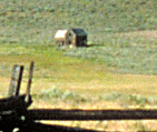 in
the State of Washington, for example, producing an impressive
1 below zero in the sea-level city of Olympia, but only 3 below
on the east side in Yakima. (Olympia's all-time record low is
only a few degrees colder!) .... Meanwhile, the cold did penetrate
Oregon, with Redmond recording 14 below, and Portland recording
a comparatively mild 13 above. Seneca, however, in its usual "Arctic
King" manner, took this early-season cold wave and turned
it into a very impressive 31 below zero on the morning of November
15th, 1955! .... In
the image to left,
we see a deserted homestead in the north part of Bear Valley,
about 6 miles north of town. In 1955, this homestead would have
been in considerably better repair, but probably had not been
lived in since Seneca's lumber boom days in the 1930s and 1940s.
in
the State of Washington, for example, producing an impressive
1 below zero in the sea-level city of Olympia, but only 3 below
on the east side in Yakima. (Olympia's all-time record low is
only a few degrees colder!) .... Meanwhile, the cold did penetrate
Oregon, with Redmond recording 14 below, and Portland recording
a comparatively mild 13 above. Seneca, however, in its usual "Arctic
King" manner, took this early-season cold wave and turned
it into a very impressive 31 below zero on the morning of November
15th, 1955! .... In
the image to left,
we see a deserted homestead in the north part of Bear Valley,
about 6 miles north of town. In 1955, this homestead would have
been in considerably better repair, but probably had not been
lived in since Seneca's lumber boom days in the 1930s and 1940s.
* My definition of "recent" is "since
1951." Weather records for most Eastern Oregon weather sites
got digitized only back to 1949/1950. But please recall that due
to the ill health of Mr. Howard Lohf (Seneca's long-time observer)
there are no weather records from Seneca for either 1949
or 1950. This is very unfortunate because both years had extraordinarily
cold winters which undoubtably would have broken several records.
Local reports from Seneca in my possession state firmly that it
hit 50 below zero on January 31, 1950, which, if confirmable,
would constitute the most recent time that Oregon has hit 50 below
zero! (on this date, Prineville, Oregon recorded 30 below zero,
and historical records consistently show that it is not unusual
for Seneca in a major cold wave to be 15-20 degrees colder than
Prineville).
Want to respond
to this page?
 E-mailer:
click for a direct link
Brucej@oregonphotos.com
Back to Seneca Main Page
Back
to Main Oregon Climate Page
Back
to OregonPhotos Main Page
E-mailer:
click for a direct link
Brucej@oregonphotos.com
Back to Seneca Main Page
Back
to Main Oregon Climate Page
Back
to OregonPhotos Main Page

Page
Last Revised 10/14/2022
 image
image