OREGON
COLD LOOSES ITS EDGE AND ENTERS THE NEW MILLENIUM WITH A SIGH
IT'S
BEEN TWENTY-EIGHT YEARS SINCE THE LAST REAL COLD WAVE
And,
more on Seneca and the future of Oregon's Arctic King
Seneca's former
mighty Arctic cold waves may have been toned-down by global warming
(see bottom of previous
page),
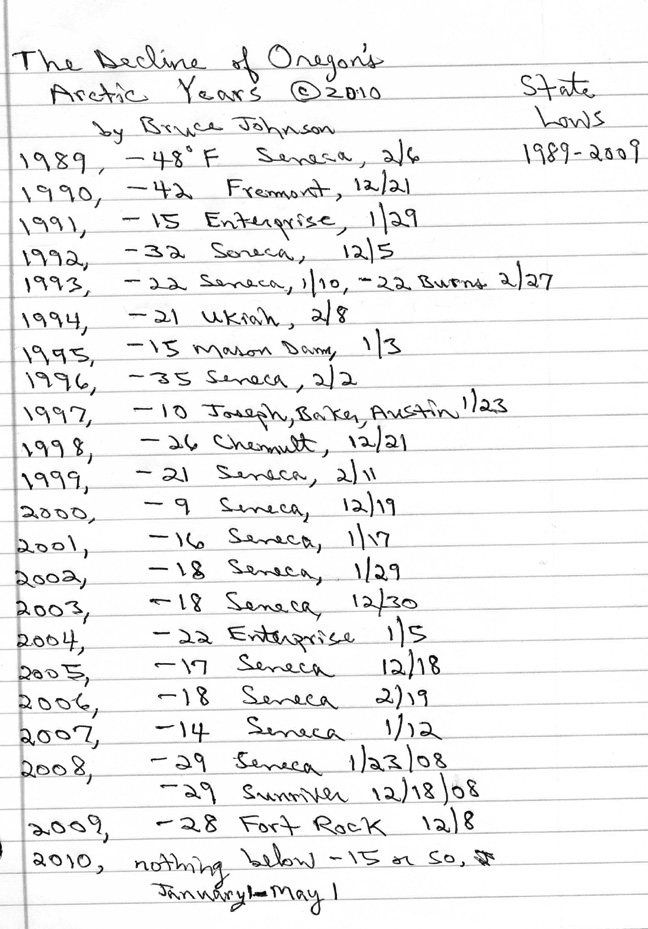
and OREGON as a whole has followed this warming trend. The State's
extreme winter cold waves have continued to moderate, both in
depth (how many degrees below zero) and in duration. Below is
new research which shows that even Oregon's Arctic King is having troubles, and if the facts of Global
Climate Change are correct, this change may be permanent.
THE NEW
MILLENIUM APPEARS TO BE WARMING UP, AND IN A BIG WAY
UPDATE, January 2014. Seneca had been a wimp of
its former Arctic King self since 1990, but late in 2010 and early
in 2011, there was some small cause for hope. Read on..... The year's low for 2009
was a measely 1 below zero. But in late December of 2010, the
first really significant arctic blast since 1996 descended on
Seneca. It was fairly mild compared to the mighty cold waves of
the past (click
to see
some of them).... The arctic air of 2010 hit rather suddenly on
Dec. 31, with the temperature plummeting to 27 below zero. The
cold wave was six days long, again nothing compared to the long-lasting
severe cold of the big Arctic blasts, but still, for six days
it was subzero every night. The coldest was 30 below on January
1, 2011. The other four nights were never worse than 16 below....But
then to cap off the Winter of 20120-2011, on Feb. 26, 2011, Seneca reared up its Arctic
head quite unexpectedly, hitting 33 below zero on Feb. 26th; it was a real oddball
event, eg. the 25th was a little cold but hardly more than a bit
sub-normal, then whamo, 33 below on the 26th, then the next night
was well above zero and it was all over, like a dream! ...............................
Note: the 1996 cold wave had hit in very late January of 1996.
In Seneca it generated a respectable 35 below zero on the coldest
night....But by old-time Seneca standards, this was only a moderate
cold wave, neither very deep or very long. It set no new records
on any of its five days... Here are the figures for the 1996 cold
wave: January 30, low temperature was 8 below zero... January
31, low was 19 below zero... February 1, low was 20 below zero...
February 2, low was
35 below zero...
February 3, low was 32 below zero... February 4-- the cold wave
abruptly broke...(click
here to
see some examples of truly major cold waves in Seneca!).....
The Year 2000
began the New Millenium with a real flop in the cold wave category.
Oregon's coldest temperature of the year was a paltry 9 below
zero (at Seneca, of course).... The following three winters were
similarly weak-kneed in the cold department. It wasn't until January
2008, and again in December 2008, that the Arctic King seemed
to revive a little bit, with temperatures falling to almost 30
below zero two times; the first times in 12 years the State had
approached the 30 below mark. ...... In Seneca's "Glory Days"
as Arctic King, temperatures in the -15 to -30 range would have
been merely preludes to the REAL cold that was to follow during
a major Arctic air invasion. Will there ever again be a cold wave
to measure up to the great snarling demons of the past century?
Will there ever again be savage cold such as gripped Seneca so
mightily in the cold waves of 1919, 1924, 1930, 1933, 1937, and
several more recent years. Will 1989's cold wave truly go down
into the history books as the final big cold wave to hit the region
before Global Warming forever took away such events? (some experts
might include 1990 as the last major event, but I have my reasons
why I do not, one being that Fremont 5Nnw is only a ranch in the
middle of nowhere, not a real town like Seneca).
Click here to
skip
to a listing
of the major cold waves to hit Seneca since the Big One of 1933!
Arctic
King Seneca at its Best--- REAL COLD WAVES- A SAMPLER!
1985. What a year! February
of '85 shivered with a bleak 43 below zero early in the month (February 4). This was an evil
thing which residents strove to forget during the pleasant summer
which followed... But the arctic cold returned early, clamping
down hard by late November, when Thanksgiving saw a six day long
period that got as low as 31 below (average low was 14 below).
... And November was just a prelude, with December 1985 being
a brutally cold month for Seneca, which suffered through a record-setting
string of sub-zero nights that lasted a full 21 days in a row,
the cold finally breaking on the 22nd day, which was New Years
Day 1986-- it was a balmy 1 above zero!
1983. An arctic sneak attack!...
December 22nd, high 0, low 27 below zero. December 23rd, high a frozen 5 below zero with an achingly
bitter 48
below morning.
December 24th, Christmas Eve, high of 3 above, with low of 40
below zero. Then a heat wave came for Christmas Day, with a high
of 17 above! Note to Portlanders: this particular cold wave was
also very brutal in the Portland area, featuring ferocious "Gorge
Winds" from the east for several days in a row, timed perfectly
to freeze-dry last minute Christmas shopping. On the worst day,
Dec. 23, Portland rose to only 19 degrees, with a low of 16 degrees,
and east winds blasted to 48 mph at the airport. And on the 24th,
the high was only 21, with the relentless winds gusting to 50
mph.
1989. The
last of the cold waves of Giant Stature to hit Seneca: temperatures dipped to 48 below zero on February 6, with an average low temp of 39 below
zero for five consecutive days during the fifteen day long cold
wave! -- 1989 highlights an important facet of Seneca climate,
which is the historic prevalence of huge cold events during the
first two weeks of February. Some of Seneca's coldest-ever records
have been repeatedly set -- not in December or January-- but instead
in February, very close in time to when its all-time record low
was set (February 10, 1933, 54 degrees below zero F). (note: the
cold wave of 1990 was serious, but not quite to the level of 1989's)
December-Jan-Feb of 1978-79. This time period of about 60 days
featured an awesome selection of repeated arctic blasts combined
with considerable repeated snowfalls. The time span from Dec.
7, 1978 through Feb. 3, 1979 showed us the Arctic King Seneca
in full glory. There were five separate sub-zero cold waves (two
big ones and 3 lesser ones). There was a total of 5.5 feet of
snowfall. The first of the two big cold waves hit a few days after
Christmas 1978, showing a 41 below zero on Dec. 30th and a 40
below zero "welcome to the New Year" on January 1, 1979.
This cold wave lasted for 12 days, many of the lows were at 30
below or colder..... The second of the two big cold waves hit
in late January 1979, beginning on January 23 and lasting twelve
days. There were a succession of nights at or below 30 below again,
this time bottoming out on Feb. 2 with a 39 below zero! Perhaps
even more telling than the extremes posted for the period, January
1979 as a total month showed a truly frigid face with an average
high of only 23, and an average low of 8 below zero! But even
these averages do not measure up to the truly epic cold of the
more distant past; Oregon's coldest-ever month featured an average
of 0.0 F at Austin, a timber town to the northeast of Seneca;
this was January 1937 and I can estimate that Austin's average
high for the month was 15 above zero with an average low of 15
below zero!
1957. Now we're talking the
snarling-cold Seneca of historic record!... January of this year
featured two separate major cold waves, together lasting the entire
last half of January! On January 16th, the cold wave hit, with
a low of -20.... The following four nights had an average low
of -14.... Then there were four days of relative respite, with
lows ranging from 4 to 10 above zero..... but then the hammer
struck again, even harder, lasting all the way through to the
bitter end of the month. January 25 had -14. January 26 shivered at -43. January 27
at -40. January 28 still at -37. January 29 still at -33. January 30 at -29. January
31 at -26. Finally, the cold broke on February 1, when a powerful
incursion of much warmer air brought an astounding change, with
a low of 27 ABOVE zero, a full 53 degrees warmer than the day
before!
Winter 1931-32. This winter was probably
the very first winter that the Seneca station was in operation,
and it was a real "doozy." What appears to have been
four sucessive arctic blasts clobbered the lonely little town,
giving such frigid readings as 30 below zero on Nov. 29, then
38 below zero on December 15; followed by a 41 below zero on January
21st, and finally giving townfolks a nasty farewell on February
14th with a stunning 49 below zero. Then, just four days shy of
one year later, Seneca was hit with a fast-moving Siberian Express
which shot the temperature down to 54 below zero, which still
stands in 2013 as the coldest temperature ever seen in Oregon!
Winter 1929-30 was also noteworthy.
I haven't done a complete review of this winter, but have noted
that mid to late January had a major Arctic outbreak(s), with
such readings as 40 below at Madras on January 21, 1930 and 26
below at Pendleton on January 23, 1930.
The Daily Rise and Fall of temperatures is called
"Diurnal change."
Seneca ought to also be famous
for its insane
dirurnal temperature changes... Often late summer/early fall is the prime season
for these, with very clear dry air and longer nights to foster
intense radiational cooling. Example: October 7, 1964, high of
a summery 82, but a morning low of 22 degrees. The day before
had had a low of 18, with a high of 78. These daily changes of
50-60 degrees are not unusual in Seneca... And there are places
in Oregon with even more insane diurnal changes than even Seneca!
My contender for that honor goes to Fremont, in the Fort Rock Valley of Central Oregon, perhaps
60 air miles SE of Bend, and at an elevation of 4500 feet. A sample
from the record: September 23, 1993: morning low of 10 and afternoon
high a very pleasant 71--- Note: Fremont was a regular Co-op reporting
station from 1909 to 1996; it was not a town, but some kind of
Ranch. In more recent years, it appears to have been replaced
by a station named "Cabin
Lake,"
some 10 miles to the NE; Cabin Lake is part of a small park, and
my monitoring of it so far shows it to be quite comparable to
the old Fremont in terms of climate. Even more recently, there
is now a station reporting named "Fort Rock," which
is in the same vicinity, and similarly extreme.
Want to respond
to this page?
 E-mailer:
click for a direct link
Brucej@oregonphotos.com
Back to Seneca Main Page
Back
to Main Oregon Climate Page
Back
to OregonPhotos Main Page
E-mailer:
click for a direct link
Brucej@oregonphotos.com
Back to Seneca Main Page
Back
to Main Oregon Climate Page
Back
to OregonPhotos Main Page

Page
Last Revised 11/26/2021
 image
image