 6,812 ft.6,812 ft.
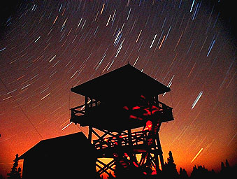
A Classic Fire Lookout, one of the best remaining in Oregon. The Mt. Pisgah site began to be used in 1918, and has had several incarnations of various types and sizes of lookouts......Lookout history: After a high point in the 1950s, the number of manned lookouts in the Northwest declined steadily, and many were torn down and burned by the Forest Service in the 70's and 80's, and others were simply abandoned to the harsh mountain weather and have been lost through decay and neglect. An example was the lookout station on top of 9,038 ft. Strawberry Mountain.
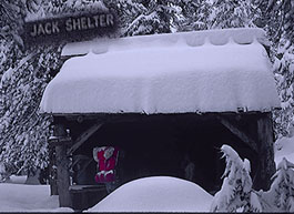
Mt. Pisgah, however, is in great shape. This beauty is found about 40 miles east of Prineville on the Ochoco National Forest, on the north side of Big Summit Prarie. Its Bibical name is probably in reference to a great view of the Promised Land attained from the Biblical Mt. Pisgah by Moses. Although the Lookout tower can be driven to with a passenger car with good clearance, a pickup or SUV will be much better as the road is narrow, dusty, and occastionally quite rocky/bumpy. We found the long-time lookout keeper Mike and his son to be very hospitable. The road usually clears of snow in mid to late June. See if you can spot the groves of Mountain Mahogany trees near the summit--- these are fugitives from the desert mountain ranges of Nevada! The ancient wooden garage on the summit is on a National Historic register and is inhabited by pack rats. Despite this lookout tower's seeming remoteness, on a very clear day, about one dozen manned lookouts are visible (eg. through a good spotting scope), along with about six more that are currently unmanned or abandoned.
 News
Note! ....There's a saying
that the more things change, the more they stay the same. This
has certainly proven true when it comes to fire spotters, as the
Forest Service has discovered that human eyes still can't be beat
when it comes to spotting the tell-tale flicker of smoke rising
in the distance. During the bad fire season of 2002, National
Public Radio reported that the number of manned towers in the
Pacific Northwest has been steadily on the increase in the last
few years. One District Ranger who was interviewed expected this
trend
to continue, although with increasing financial pressure on the
forestry services it's hard to say if that will hold true. Stationing
a Ranger at a Lookout is expensive and Forest Service budgets
continue to see more and more money being cut. Satellites, although
much less accurate, don't require meals, housing and a reasonable
wage to live on. On the other hand, perhaps we will see a return
to the low-cost designs popular in the early days of fire lookouts,
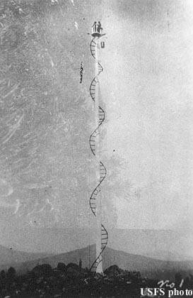
as illustrated in this Forest Service archive photo labeled "Brush
Mountain 1916." (this photo artist's rendering brings to
my mind the rock group Led Zeppelin and its famous rock song,
"The Stairway to Heaven," released in 1971).....The
place was in Southern Oregon, atop a 6,155 ft. peak located about
four miles east of the present-day Howard Prarie Reservoir. The
PCT passes along the east slope of Brush Mtn, just 100 (vertical)
feet below the summit. If you go up to see the remanants on the
summit, "take only pictures" and be gentle; the site
is on the National Historic Register... Look for pieces of the
old carved yew wood steps that led up to the top of the spar tree----
in the early history of fire lookouts in America, it was common
to place the lookout's cabin safely on the ground, but each morning
would begin with a brave climb, ending at a cramped, exposed daytime
observation platform high atop a shaved-off giant pine or fir
tree (such as a 105 foot high lookout atop a big ponderosa pine
near Sisters, Oregon. (Some of this information compliments of
correspondent Kurt H.)
News
Note! ....There's a saying
that the more things change, the more they stay the same. This
has certainly proven true when it comes to fire spotters, as the
Forest Service has discovered that human eyes still can't be beat
when it comes to spotting the tell-tale flicker of smoke rising
in the distance. During the bad fire season of 2002, National
Public Radio reported that the number of manned towers in the
Pacific Northwest has been steadily on the increase in the last
few years. One District Ranger who was interviewed expected this
trend
to continue, although with increasing financial pressure on the
forestry services it's hard to say if that will hold true. Stationing
a Ranger at a Lookout is expensive and Forest Service budgets
continue to see more and more money being cut. Satellites, although
much less accurate, don't require meals, housing and a reasonable
wage to live on. On the other hand, perhaps we will see a return
to the low-cost designs popular in the early days of fire lookouts,
as illustrated in this Forest Service archive photo labeled "Brush
Mountain 1916." (this photo artist's rendering brings to
my mind the rock group Led Zeppelin and its famous rock song,
"The Stairway to Heaven," released in 1971).....The
place was in Southern Oregon, atop a 6,155 ft. peak located about
four miles east of the present-day Howard Prarie Reservoir. The
PCT passes along the east slope of Brush Mtn, just 100 (vertical)
feet below the summit. If you go up to see the remanants on the
summit, "take only pictures" and be gentle; the site
is on the National Historic Register... Look for pieces of the
old carved yew wood steps that led up to the top of the spar tree----
in the early history of fire lookouts in America, it was common
to place the lookout's cabin safely on the ground, but each morning
would begin with a brave climb, ending at a cramped, exposed daytime
observation platform high atop a shaved-off giant pine or fir
tree (such as a 105 foot high lookout atop a big ponderosa pine
near Sisters, Oregon. (Some of this information compliments of
correspondent Kurt H.)
 ......
The high-altitude hemlock forest at Mule Peak* was dark and cool and very, very quiet. I had hiked all day alone, never seeing anyone, the only wildlife signs were small invisible bird chirps, and once the flick of a squirrel's tail as it ran for cover. Something in me began to long for a distant view and open sky above; I was between jagged Mt. Thielson to the south and glaciated Diamond Peak to the north, their peaks were like friends whose familiar faces I longed to see. When my altimeter was to 6,600 ft. I knew I was close to the summit, so I left the PCT. My route went east toward what my topo map hinted might be a steep area that might be rocky, and hence open, and I could hope for a viewpoint.
After a few hundred yards of walking through the open but dark old-growth hemlock woods, I came upon a faint track, and it seemed to be heading generally where I wanted to go, so I followed it. Soon I began to note the tell-tale signs that this was no mere game trail; there were very old blazes, dim and mostly absorbed back into the tree bark; also, here and there were a few geometrically sawed-off tree trunks, nothing recent, all old and mouldy. I began to see brighter light ahead, and soon rocky areas appeared. Far beyond the Cascade Range, bright swatches of sunny Eastern Oregon pine forests shone through gaps in the trees.
 After
a peaceful snack, I began to work my way back toward the PCT,
but I had not gone 100 yards before I glimpsed an unnaturally
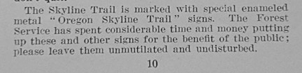
white shape on a distant tree trunk. Enameled metal, with the
original tasteful logo of the Oregon Skyline Trail, and not shot
full of bullet holes, it was a treasure indeed. 50 years back
into History my mind leapt….the 1930's, so long gone, the
trail builders rerouting the original Skyline Trail from the lowlands
route of the early 20's, high up to the spine of the Cascade Crest.
It was probably the CCC men, grubbing and marking this trail lovingly.
How many years had gone by since their work was bypassed by the
modern PCT? And how many quiet years had it been since human footsteps
had trod this trail? And how many more years would this unmaintained
and forgotten gem exist before Time took it back, and it became
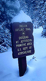
so dim that it would be lost to history, forever? Go to page bottom
for notes about the trail sign image to the left.
After
a peaceful snack, I began to work my way back toward the PCT,
but I had not gone 100 yards before I glimpsed an unnaturally
white shape on a distant tree trunk. Enameled metal, with the
original tasteful logo of the Oregon Skyline Trail, and not shot
full of bullet holes, it was a treasure indeed. 50 years back
into History my mind leapt….the 1930's, so long gone, the
trail builders rerouting the original Skyline Trail from the lowlands
route of the early 20's, high up to the spine of the Cascade Crest.
It was probably the CCC men, grubbing and marking this trail lovingly.
How many years had gone by since their work was bypassed by the
modern PCT? And how many quiet years had it been since human footsteps
had trod this trail? And how many more years would this unmaintained
and forgotten gem exist before Time took it back, and it became
so dim that it would be lost to history, forever? Go to page bottom
for notes about the trail sign image to the left.
Still deep
in thought, I pushed through some dense, young saplings and suddenly
stepped out onto the broad and somewhat dusty expanse of the PCT.
I headed back down the trail to the many people at Miller Lake,
but for some reason I kept the old Skyline Trail a secret..... Below is text from the 1931 edition
of the Oregon Skyline Trail Map:
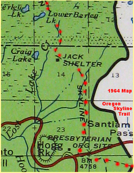
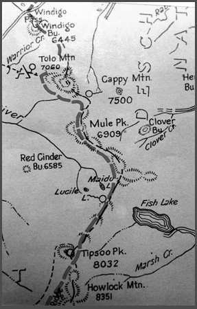
* and Mule Peak is part of my continuing secret, because I have chosen to call the location Mule Peak for purposes of the story above (the real Mule Peak is elev. 6,860'). The true location is somewhere along a 3 mile stretch of the PCT near/around Mule Peak! Go exploring for yourself. That will be the real Fun! Below is a scanned image of the 1931 version of the 1921 "The Oregon Skyline Trail" map. It will show you the area including Mule Peak. An interesting feature is the big lake shown as "Fish Lake," which in modern times has been "Miller Lake" for many decades! This scan shows little-travelled Windigo Pass in the north, probably Oregon's least-travelled passenger-car route across the Cascade Crest. The south edge extends to lofty Howlock Mountain in the south. Click here for more on Howlock Mtn.
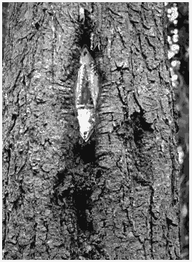
The trail sign being "eaten" by the tree was contributed by reader and PCT lover Monte Dodge. Readers will note that the sign being eaten is a "Pacific Crest Trail" sign, rather than one of the earlier "Oregon Skyline Trail" signs I witnessed that day on Mule Peak. To me this image helps explain one reason why original Skyline Trail signs are so rare-- my theory is that many of the remaining "Oregon Skyline Trail" signs are now invisible, totally absorbed back into the bodies of the trees upon which they were tacked.
Here's a short "Ode" to the pleasures of tracking down and hiking ancient trails, contributed by an Oregon hiker named Kelly:
Ode to a Lonely Trail:
I've waited long and
lonely to serve my purpose.
People used to visit and tend to me on a regular basis. Then they
stopped. Seduced by younger trails with nicer grades.
I feared I should perish and be taken back by the wild before
ever again feeling the sweet, weight of hiker's boots upon my
spine as I guide them safely through the woods.
But I'm still here. Waiting to show a new generation of hikers
a new adventure and a piece of trail history almost, but not quite,
lost.
Thank you. Please come again.
Sincerely,
Your Loving Trail
*****************************************************************************************