Strawberry Mountain Wilderness
 It's one of Oregon's least-travelled Wilderness
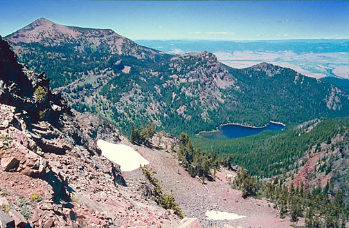
areas. It tops out at just slightly over 9,000 ft.. Shown in the
picture are 9,038 ft. Strawberry Mountain (it's the peak on the
left), and also the range's largest lake, 6,263 ft. high Strawberry
Lake.
It's one of Oregon's least-travelled Wilderness
areas. It tops out at just slightly over 9,000 ft.. Shown in the
picture are 9,038 ft. Strawberry Mountain (it's the peak on the
left), and also the range's largest lake, 6,263 ft. high Strawberry
Lake.
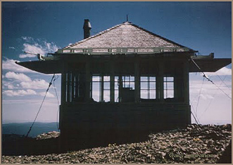
The peak was topped with a Forest Service
Fire Lookout station up to 1966 or so (see picture of the lookout
below: credit Gary Laurance). It was one of Oregon's 3 or 4 highest
lookout towers.
The dry country of the John Day River
and its deep valley are far below, at about 3000-3600 feet elevation--
that's where the towns are: Prarie City, Canyon City, John Day,
Mt. Vernon and Dayville... We're in Grant County, the nearest
big city is Bend, Oregon, population 80,000, over three hours
drive away-- when the weather is good.
The Strawberry Mountain Wilderness Area
was formally designated as an Oregon "Wild" area on
2/09/1942, making it among the older Oregon Wilderness areas.
At a size of 33,033 acres, it is one of Oregon's smaller Wilderness
areas.
Below, a family enjoys the fishing and
evening light at Little Strawberry Lake,* 6,900 ft. high, in the
drainage of Strawberry Creek....This lake, like many of the others
within the Wilderness, lies in a glacial cirque;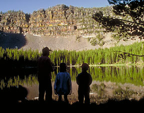 this is one of the attractions of the Strawberries-- the beautiful
glacial U-shaped gorges.... the Strawberry Range is one of the
few places in the Pacific Northwest where five of Merriam's seven
classic life zones can be found, and the zones are compressed
into just a few miles of one another. The forest cover in the
Strawberry Range is extensive and unusually varied. Despite the
basic dryness of the region, the forests include many pines such
as ponderosa pine, western white pine, and lodgepole pine, while
at higer elevations Douglas fir and white fir are found. At the
highest elevations, you'll find wonderful groves of Alpine fir,
Engelmann spruce and Whitebark pine. A truly unusual tree is also
found-- the Mountain Mahogany, a scrubby but pictureque tree found
in isolated groves on dry shoulders and benches at around 7,000
feet (this tree is found in profusion in the desert ranges of
Nevada, hundreds of miles to the south). Notable wildlife to be
seen include Rocky Mountain elk, the reestablished California
Bighorn Sheep, coyotes, bobcats, pine martens, black bear, mink,
beaver, golden eagle, and of course mule deer. Cougar sightings
have occurred.
this is one of the attractions of the Strawberries-- the beautiful
glacial U-shaped gorges.... the Strawberry Range is one of the
few places in the Pacific Northwest where five of Merriam's seven
classic life zones can be found, and the zones are compressed
into just a few miles of one another. The forest cover in the
Strawberry Range is extensive and unusually varied. Despite the
basic dryness of the region, the forests include many pines such
as ponderosa pine, western white pine, and lodgepole pine, while
at higer elevations Douglas fir and white fir are found. At the
highest elevations, you'll find wonderful groves of Alpine fir,
Engelmann spruce and Whitebark pine. A truly unusual tree is also
found-- the Mountain Mahogany, a scrubby but pictureque tree found
in isolated groves on dry shoulders and benches at around 7,000
feet (this tree is found in profusion in the desert ranges of
Nevada, hundreds of miles to the south). Notable wildlife to be
seen include Rocky Mountain elk, the reestablished California
Bighorn Sheep, coyotes, bobcats, pine martens, black bear, mink,
beaver, golden eagle, and of course mule deer. Cougar sightings
have occurred.
* The revised dates of use for the Strawberry
Mtn. Lookout tower are compliments of a reader who personally
knew some of the lookout personnel in the 1950s. New input is
always solicited. Thank you. At page bottom
you will find a section about the history of this area that was
provided by a gentleman who grew up in Prarie City in the 1950s.
Gold! An interesting historical
fact about the Strawberry Range is that its western end harbored
some of Oregon's richest gold deposits; in fact, it is alleged
that for a brief time in the 1800s Canyon City was one of the
largest, most bustling cities in the State!
(for history buffs, here are the names of the major mines: Golden West Mine, Iron King Mine, Great Northwestern
Mine, Haggard and New Mine, Ward Mine, Marks-Thompson Mine (right
near a hot springs), and the Chambers Mine high on 7400 ft. Baldy
Mountain-- all mistakenly marked as "abandoned" on a
1975 map except for the Marks-Thompson Mine. Update: late 2009.
I have been contacted by the owner of some of these mines, who
states that most are on private land, off-limits except by direct
permission, and furthermore are potentially quite dangerous. He
further adds that some are still sporadically being worked by
their owners). Below is a picture I took up above Little Strawberry
Lake during a late June trip. The elevation was about 7,600 feet.
Back
to John Day River Country Page
Back
to Forest Fire Lookouts Main Page
WWW.OREGONPHOTOS.COM

Here
are some relevant historical factoids about this remote corner
of Oregon, as provided by a reader.
"Strawberry Butte was originally
named Logan* Butte because
from 1865 to 1869 a military camp, Camp Logan, was located on
"Strawberry
Creek" a couple miles from the spot where the creek exits
the mountains.
But pioneer homesteaders found wild strawberries on the mountain
and they
called it Strawberry Butte (or mountain) - and that is the name
that stuck.
(The butte is not really a mountain. It is actually an up-lift.)"
*Logan was an important figure
in Oregon pioneer history, being, among other
things, a leading Indian agent.
"The an old Indian (Native
American) trail came out of Logan Valley on the
south side of the range, past Slide Lake, down Slide Creek, and
over to what
is now the Blue Mountain Hot Springs* (now closed to the public)
at the head
of the valley. The Indians bathed and tanned hides in the hot
spring.
(Actually, the Indians fished, hunted, gathered berries and roots
all
through the area. They were what is now called the "Burns
Piautes" but they
called themselves the 'wadatoka' if memory serves. Wada was their
name for
the cattail roots they dug around Harney Lake. The Burns/Harney
Lake area
is where the local Paiutes had their winter quarters. (Indian
tribes often
called themselves after what their main food supply was [you are
what you
eat], so there were the wada eaters, the salmon eaters, the deer
eaters,
etc., etc.)"
*Fish were planted in those lakes
(Strawberry, Little Strawberry and Slide)
in the 1920s. They were packed in in tanks on horses' backs."
* The owner/photographer of OregonPhotos.com
vacationed at the old Blue Mountain Hot Springs resort in the
1970s. He regrets that this locale is now closed to the public
as it was big, quaint and reeking of the nostalgia of the old
hot springs resorts of the turn of the Century (1900)....There
are at least two other hot springs on the flanks of the Strawberries,
neither of which seems to be commercially developed at this time.....
A better-known old hot springs resort, also in Eastern Oregon,
is trying to make a comeback into the modern times: here is my
story about it: Medical Hot Springs
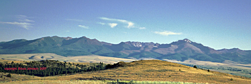 The Strawberry Range
as seen from the northeast. We are coming down from Dixie Pass
on a mid-summer evening. Strawberry Mountain is the snow-tipped
peak on the right. This is a classic Eastern Oregon vista of brownish,
grassy valley dotted with juniper trees, with pine-forested mountain
ranges beyond.. Elk love this kind of country. I'm not an elk,
but I do, too!
Page last revised 01/11/2025
The Strawberry Range
as seen from the northeast. We are coming down from Dixie Pass
on a mid-summer evening. Strawberry Mountain is the snow-tipped
peak on the right. This is a classic Eastern Oregon vista of brownish,
grassy valley dotted with juniper trees, with pine-forested mountain
ranges beyond.. Elk love this kind of country. I'm not an elk,
but I do, too!
Page last revised 01/11/2025