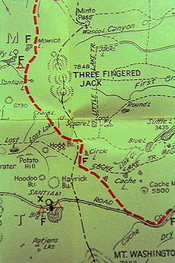
The small gray picture above is from the 1931 Forest Service trail map, but notes that there were earlier maps in 1922 and 1923. The offical Skyline Trail was created in 1920 by the Forest Service, and the route was flagged about then. Before 1920, the route was more unofficially named "The French Line," for reasons I will describe later on this page. The official Skyline Trail of 1920 was comprised of a rough combination of old wagon roads, Indian paths, logger's byways, etc... It included very little actual trail building in the modern sense of the term, nor was it placed very near the true "skyline" of the range, nor was it very close to the route of the modern Pacific Crest Trail (PCT)..... Nowadays, some sections of the old Skyline Trail are paved over with major highways, such as near Diamond Lake and Crater Lake. And in total length, the trail was shorter than the present Pacific Crest Trail-- at the time of the above map (1931), the Trail still only extended from near Government Camp on the south side of Mt. Hood, to the north end of Crater Lake, a distance of 235 miles.... Note: in February 2005, I also acquired a mint condition official 1921 Skyline Trail Map; it's 24x17.5 inches, with great historic material on both sides. Please click here to see samples and if interested in purchasing yourself a copy. Contact me at: brucej@oregonphotos.com
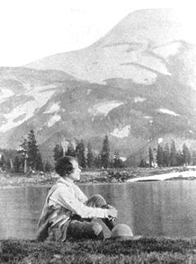 ..location? maybe Mt. Jefferson
Observant readers will note several major geographical differences in the 1931 Map shown at top of page:
The modern-day Santiam Pass Highway, Hwy 20, doesn't exist yet! In its place is its predecessor, the "Santiam Road," running south of the present-day Hoodoo Ski Area and down along the south side of 5,500 ft.Cache Mtn. In even earlier times, this was the "Santiam Wagon Road." (side-story about Cache Mountain: after abandoning its astronomical observatory atop 2,000 ft. Spencer's Butte in Eugene in the late 1800s due to rain, fog and clouds, the University of Oregon once upon a time considered building a new observatory atop Cache Mtn., but decided it, too, was far too cloudy and rainy.... Finally, fifty years later, they went eastward into the Central Oregon High Desert, and constructed their dream at 6,300 feet, atop high and dry Pine Mountain about 80 miles SE of Santiam Pass (click Pine Mountain link for more information and a link to the Pine Mountain webcam!).......... The old Santiam Road still makes an excellent winter-time cross-country ski route, coming down near the present site of the Black Butte Ranch Resort.
In the 1931 map, The Mt. Jefferson Wilderness area doesn't yet exist, and its predecessor is much smaller, and doesn't even encompass one of the gems of this region, Three-Fingered Jack, which is one of the prominent peaks marking the Cascade skyline, and at 7,800 Ft, a peak that was a common climber's goal for more skilled climbers even before WW II. (first ascent via the South Ridge in 1923)........* Map compliments of contributor and hiker Mike Kinyon.
Other Trails: the 1931 map is also littered with other trails, the most prominent and noteworthy was the wonderful complex of trails that wandered along the eastern side of the crest, which the 1931 map named the "Little Lake Trail," but more modern maps called "No. 65." For more modern hikers, eg. in the 1960s and 70s, this trail began at Santiam Pass and ran all the way north to "Hole in the Wall Park," which is where Warm Springs Indian land stopped it... Many interesting feeder trails came into No. 65, eg. the Cabot Lake Trail, the Carl Lake Trail, the Brush Creek Trail, and more. Some parts of No. 65 later became portions of the modern PCT.
THE FRENCH LINE, pre-1920 history: source: John T. Rinkes, 2014 contact with me. At the time, Mr. Rinkes was quite elderly. He was a member of the Territorial Riders of Oregon City in 1947-48. He told me, "I was acquainted with the first (White man) who actually patented the Oregon Skyline Trail-- [but] before it was called that. He was a trapper and an immigrant from France. The Skyline Trail (as it was later named) was for years named "The French LIne." Rinkes continued, "I personally camped at some of his sites in 1947 and 48," and later saying that the trapper had built some rustic shelters along the old trail in the pre-WW II era: "Some of his personal camp sites with a shelter were administered by the Mt. Hood and Willamette National Forests, when they came into being; in some cases, the shelters were rebuilt. That is why they endured as long as they did. The shelters were provisioned with WW II surplus supplies, including canned meat, vegetables, and dry goods. The shelter supplies were for travelers who had needs of emergency use only." Rinkes was especially hoping to re-find a shelter he'd used in 1947, on a high ridge just north of Mt. Jefferson/Jefferson Park....Later, Rinkes clarified to me that it was mainly through his mother, a contemporary of this trapper, that he as a young person originally became acquainted with the trapper and the trapper's wife.