2003. The Year of the
B and B Complex Fire
August 19-September 26,
2003, with updates into 2023
 In the natural course of Mother Nature,
before the arrival of the White Man to the Northwest, fire played
a regular, irregular role in opening up the forest. Every area
of the forest burned now and then. In the High Cascades, with
their wet climate, heavy snows, and a fairly low prevalence of
lightning (at least in the more northerly areas like Mt. Jefferson),
any particular piece of forest might experience a fire only once
in two hundred years or more. If the interval since the last fire
was brief, the fire might be only a mild ground fire that disposed
of excessive undergrowth and left the large old growth trees intact.
In the natural course of Mother Nature,
before the arrival of the White Man to the Northwest, fire played
a regular, irregular role in opening up the forest. Every area
of the forest burned now and then. In the High Cascades, with
their wet climate, heavy snows, and a fairly low prevalence of
lightning (at least in the more northerly areas like Mt. Jefferson),
any particular piece of forest might experience a fire only once
in two hundred years or more. If the interval since the last fire
was brief, the fire might be only a mild ground fire that disposed
of excessive undergrowth and left the large old growth trees intact.
But if the interval were long,
the fire might be a huge conflagration, crowning and leaping and
burning for months, stripping 100 or more square miles of the
Cascades down to bare soil and scorched rocks-- such as the B
and B Complex fire has done to a percentage of its burn area in
2003. The B and B burned its furious way through many forests
that have not seen fire since before the White Man began fire
suppression efforts in the early part of the Twentieth Century.
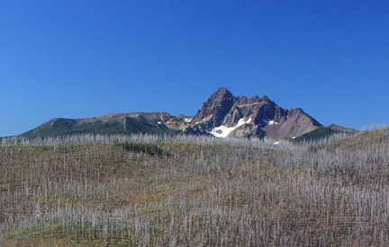
Image: Three-Fingered Jack rises seemingly unscathed above
the still-denuded slopes of Brush Creek nine years after the Fire;
picture taken summer 2012. Compare this view with the picture
lower on page that was taken on the complete opposite side of
Three Fingered Jack. Image Credit: J. Thomas Jeffrey
Both of the "parent"
fires of the B and B started on August 19th within hours of one
another, and before the resultant B and B Complex Fire was contained,
it burned 90,769 acres. Reports showed that 43% of this area was
burned at high to moderate intensity levels. The total canopy
kill ratio on the trees will take a least one growing season to
reveal. (Note: as of September 21st, the Fire was not growing,
but still was reported as only 95% contained; it was finally reported
as contained on September 26, 2003).
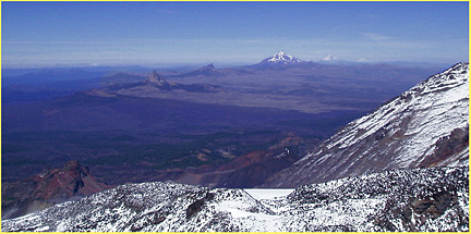
Below are two pictures; the
first taken seven years later, in 2010, from high on the Three
Sisters. We are looking
north, and see the enormous extent of the section of the B&B
Fire that burned on the eastern side of the Cascade Crest (and
there is much more on the western side of the Crest, also, but
not visible in this view)....Also, by looking closer, we can also
see (in the mid-foreground) the much older damage of the Big
Lake Airstrip Fire of about 1968. The peaks visible on the
distant skyline are Mt. St. Helens (barely), Mt. Jefferson (prominent),
Mt. Hood and Mt. Adams (dimly seen to the right of Mt. Hood).
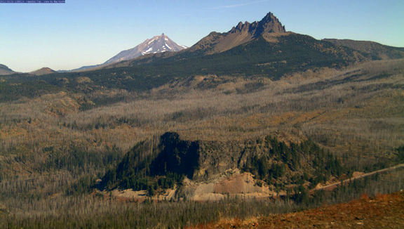
 And below is a second
picture, this one taken from near Santiam Pass, nine years later
(in 2012). The vantage
point is high atop Hoodoo Butte at over 5800 ft, the place the
ski lifts go to at the Hoodoo Ski Area. We are looking north at
Hogg Rock (the flat plateau); Three-Fingered Jack, and Mt. Jefferson.
This view shows us the south and southwestern borders of the huge
fire area. Highway 20, the Santiam Pass Highway, is the highway
visible.
And below is a second
picture, this one taken from near Santiam Pass, nine years later
(in 2012). The vantage
point is high atop Hoodoo Butte at over 5800 ft, the place the
ski lifts go to at the Hoodoo Ski Area. We are looking north at
Hogg Rock (the flat plateau); Three-Fingered Jack, and Mt. Jefferson.
This view shows us the south and southwestern borders of the huge
fire area. Highway 20, the Santiam Pass Highway, is the highway
visible.
 But there are some
positive effects for outdoormen and wilderness users to enjoy!
But there are some
positive effects for outdoormen and wilderness users to enjoy!
During my time as a cross-country
ski guide*, I witnessed an almost magical transformation of the
Big Lake/Hoodoo/Cache Mountain area in the early 1970s after the
Big Lake Airstrip Fire... Dozens of square miles of formerly impenetrable
forest became a vast, open playground for skiers and snowmobilers,
with great views of Mt. Washington and Three-Fingered Jack presiding
over all the new open space!
Within the Mt. Jefferson Wilderness,
the new open spaces created by 2003's B and B Complex Fire will
be much larger (the severe to moderate intensity burn areas amount
to about 62 square miles), and also will extend to much higher
altitudes, for a longer ski season....I can imagine that east-to-west
winter traverse routes across the former Native American travel
route of Minto Pass will become superb tourist draws--- for example,
I forsee a new east-to-west route running from the Camp Sherman
area, up over the Cascade summit, down to the wonderful Eight
Lakes Basin, and thence exiting onto the burned shores of Marion
Lake! Such trips will require 3-5 days due to the sheer size of
the burned areas. Please email me for specific route suggestions.
(see emailer at page bottom)
 But
this opportunity will be time-limited---Just as with the Big Lake
Airstrip Fire, after 20-30 years, thick new reproduction will
smother out the openness, and so for the next one generation,
wilderness users--"Enjoy It while you can!"
But
this opportunity will be time-limited---Just as with the Big Lake
Airstrip Fire, after 20-30 years, thick new reproduction will
smother out the openness, and so for the next one generation,
wilderness users--"Enjoy It while you can!"
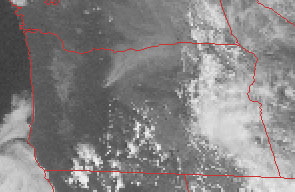
This satellite image shows the
B and B Fire on the afternoon of September 4th. Look for the smoke
plume beginning in the upper center of the picture, which is the
crest of the Cascade Mountains. On this day, the fire's size exploded
to over 80,000 acres. In the picture, its smoke plume ran NE toward
Madras/Redmond, and appears to reach as far as Pendleton, which
is a full 175 air miles! It's hot and dry, with the temperature
in Redmond at 3 p.m. a fire-conducive 96 degrees, with only 20%
humidity.
 See images of ancient forest patriarchs
and portions of historic Skyline Trail threatened or lost to the
fire near Jefferson Creek and Brush Creek (with some reader update
reports from 2007, 2008 and 2013)
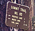
Section about how the B&B has interacted with
the historic trails such as the Summit Trail in the area near
Carl Lake and Rockpile Lake
See 2004 image of actual trail damage on trail to
Carl Lake
See images of ancient forest patriarchs
and portions of historic Skyline Trail threatened or lost to the
fire near Jefferson Creek and Brush Creek (with some reader update
reports from 2007, 2008 and 2013)
Section about how the B&B has interacted with
the historic trails such as the Summit Trail in the area near
Carl Lake and Rockpile Lake
See 2004 image of actual trail damage on trail to
Carl Lake
* My background to speak on this subject?
While not a professional forester, I am an ex-forest firefighter,
my experience includes working the Big Lake Airstrip Project Fire,
which burned an area near Big Lake just south of the B and B Fire
in 1967 or 68. Also, I was a Forest Service Wilderness Guard for
the Sisters District portion of the Mt. Jefferson Wilderness.
Other expertise includes having been a cross-country ski guide,
and being the son of a professional forester, and an Oregon climate
expert, and a history/geology buff.
 E-mailer: click
to query Bruce Johnson, author of the above opinions, brucej@oregonphotos.com
E-mailer: click
to query Bruce Johnson, author of the above opinions, brucej@oregonphotos.com

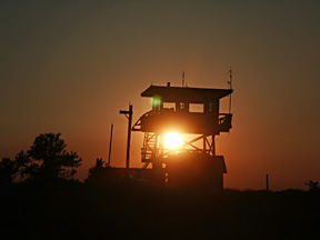
Mt. Pisgah Lookout tower enveloped
in smoke from the B and B Fire. This tower is on the Ochoco National
Forest, fully 75 air miles distant from the Fire! The Booth Fire
was first reported by an old-fashioned lookout tower-- Henkle
Butte.
 More about Oregon Fire Lookout Towers
See page two of my B and B coverage
See page three of my coverage (Santiam Pass)
See
page four of my coverage(Mt. Washington)
Hopefully
the rare Wolverine population perhaps in the area was not destroyed
A picture of the fire taken from the Oregon Star
Party
More about Oregon Fire Lookout Towers
See page two of my B and B coverage
See page three of my coverage (Santiam Pass)
See
page four of my coverage(Mt. Washington)
Hopefully
the rare Wolverine population perhaps in the area was not destroyed
A picture of the fire taken from the Oregon Star
Party
WWW.OREGONPHOTOS.COM

Page last reviewed
1/14//2023