The Year of the B and
B Complex Fire. Santiam Pass (pg. 3)
 The early days of the B and B Fire saw
it overrun the broad expanse of Highway 20 about August 19-21.
Later, it roared south and west, seriously endangering both Hoodoo
Ski Area and Lost Lake campground. In the picture to the left,
fire damage envelops the entire ridge shown, although a slim margin
of greenery remains along the roadside at this particular spot.
The early days of the B and B Fire saw
it overrun the broad expanse of Highway 20 about August 19-21.
Later, it roared south and west, seriously endangering both Hoodoo
Ski Area and Lost Lake campground. In the picture to the left,
fire damage envelops the entire ridge shown, although a slim margin
of greenery remains along the roadside at this particular spot.
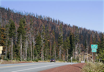
You are looking east and north
from the summit of Santiam Pass (signs say, "Summit Santiam
Pass, elev. 4817, Entering Jefferson County").
Two to three miles away on the
other side of this ridge is the approximate location where the
Booth Fire began, later to become the biggest part of the B and
B Complex Fire. ("B and B" = the Booth and Bear Fires,
which merged together about 11 miles north of this picture to
become one giant fire, probably during the evening of September
3rd).
This image sho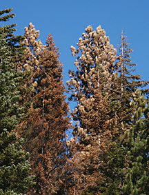 ws the a typical tree burn area along Highway 20.
The fire was very much a "hit and miss" thing along
most of this 5-10 mile stretch. Large firs and pines have been
torched, while just yards away their neighbors will live. The
net long term effect in areas like this will be many zones with
little brush and debris on the forest floor, and with groves of
large trees replacing the dense, unbroken tree cover of pre-Fire
times. There will also be tens of thousands of dead snags--- in
general, the forest will be easier to move through both summer
and winter for outdoor recreationists. Summer travel will stir
up unpleasant clouds of dust/ash for at least a few years. There
will be some danger for weeks/months or even years from falling
limbs and dead trees.
ws the a typical tree burn area along Highway 20.
The fire was very much a "hit and miss" thing along
most of this 5-10 mile stretch. Large firs and pines have been
torched, while just yards away their neighbors will live. The
net long term effect in areas like this will be many zones with
little brush and debris on the forest floor, and with groves of
large trees replacing the dense, unbroken tree cover of pre-Fire
times. There will also be tens of thousands of dead snags--- in
general, the forest will be easier to move through both summer
and winter for outdoor recreationists. Summer travel will stir
up unpleasant clouds of dust/ash for at least a few years. There
will be some danger for weeks/months or even years from falling
limbs and dead trees.
 See images of ancient forest patriarchs
and portions of historic Skyline Trail threatened or lost to the
fire near Jefferson Creek and Brush Creek
See images of ancient forest patriarchs
and portions of historic Skyline Trail threatened or lost to the
fire near Jefferson Creek and Brush Creek
 E-mailer: click
to query Bruce Johnson, author of the above opinions
E-mailer: click
to query Bruce Johnson, author of the above opinions

Contact: brucej@oregonphotos.com
as your message recipient.
Mt. Pisgah Lookout tower was enveloped
in smoke from the B and B Fire. This tower is on the Ochoco National
Forest, fully 75 air miles distant from the Fire!
More
about Oregon Fire Lookout Towers
See page two of my B and B coverage
See
view 3 miles east of the above pictures
WWW.OREGONPHOTOS.COM

Page last revised 10/18/2021