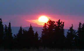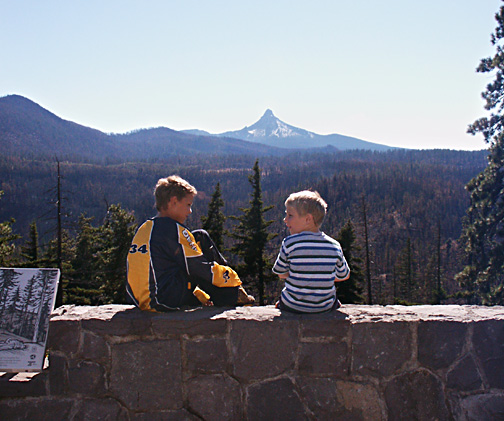
Here we gaze over the southern edge of the B and B Fire from Highway 20. We are a few miles east of the Santiam Pass....Amazingly, little damage is evident to the eye in a picture like this, but through binoculars the denuded ridges and dead black trees were very obvious. This area of the B and B Fire actually re-burned some of the area burned about three decades ago in the Big Lake Airstrip Fire*. These two boys gaze at a pretty mountain view of 7,794 ft. Mt. Washington, but it is a view which will increasingly be dominated by dead white snags during the next decade.... Note for Climbers: shown is Mt. Washington's east side, where in 1965 Tom Bauman and T. Gann put up the impossibly hard East Buttress route, a III-6 on the NCCS difficulty classification scale. (*personal note: as a kid in college working a summer job for the Forest Service, I fought the Big Lake fire, having been flown up from the Rogue River N.F. in Southwestern Oregon). Also of note is the rounded mountain on the left side of the picture, Cache Mountain, which was the initial site of the University of Oregon's astronomical observatory, but soon got moved to high and dry Pine Mountain east of Bend because Cache Mtn. was far too wet and stormy, and snowy in the winter.
Below is an image taken four years later
(2007). This new image begins to show the damage better. This
is because the trees have now had enough time to fully die and
fully loose dead needles and twigs, thus making the damage more
evident. Shown is Wasco Lake, a real gem roughly 15 miles north
of the scene with the two boys that is shown above. Wasco Lake
lies at 5,000 ft. elevation, 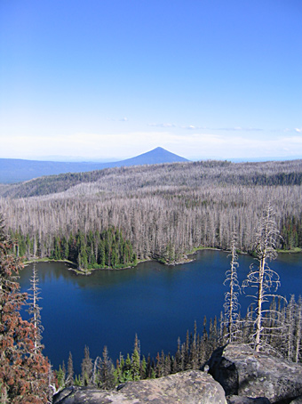 and
is just slightly to the east of the Pacific Crest Trail at Minto
Pass. I remember a lazy summer day I spent floating around the
wooded lake in a small, yellow inflatable raft that I'd packed
in....Most people get to Wasco Lake by taking the fairly short
day hike from Jack Lake (where the road ends). Prominent in the
background is 6,400 ft. Black Butte, an extinct stratovolcano
highly visible from all over Central Oregon. Black Butte Ranch
Resort lies just south of Black Butte's foot. Photo credit: Karen
J.
and
is just slightly to the east of the Pacific Crest Trail at Minto
Pass. I remember a lazy summer day I spent floating around the
wooded lake in a small, yellow inflatable raft that I'd packed
in....Most people get to Wasco Lake by taking the fairly short
day hike from Jack Lake (where the road ends). Prominent in the
background is 6,400 ft. Black Butte, an extinct stratovolcano
highly visible from all over Central Oregon. Black Butte Ranch
Resort lies just south of Black Butte's foot. Photo credit: Karen
J.