*WASHINGTON STATE--- Record Low 48 below zero at Mazama and Winthrop* on December 30, 1968. Record highest 118 at Ice Harbor Dam on August 5, 1961. Note! Many high temperature records were made in 2021; eg. 115 in Vancouver and 110 in Olympia June 28th (it had never before hit 100 in June in Olympia ---- Notes about heat in Oregon's northward neighbor--- My nomination for Washington's hottest larger city has got to be Tri-Cities (Pasco, Kennewick, Richland). This hotbox lies In south central Washington along the mighty Columbia River and very close to the Oregon border. Ice Harbor Dam is in this same zone, just a bit east of the Tri-Cities. Recent example of record-setting heat: July 23, 2006, with a high of 112 degrees, and an average temperature for the day of an Arizona-like 90 degrees (Tri-City normals for the date are 95 high and 61 low ). Comparison values--- Seattle's normal high for the date is nearly 20 degrees cooler, a mild 76, with a normal low of 56....Even more recently, August 17, 2008, 111 degrees in Hanford, which is nearby to Tri-Cities......The whole area around Tri-Cities is a very fertile agricultural area, justly famous for the abundance of warm weather crops it produces, such as watermelons! (* Mazama and Winthrop, elev. 1800 ft, lie in a deep "cold sink" mountain valley on the east slope of the Cascades, just south of the Canadian border). Mazama, Twisp, Winthrop, in the Methow Valley near Okanogan and Omak.
With an annual rainfall of a bit over 51 inches, and in 2016 recording over 61 inches of rain, Olympia, Washington grabs the title as the West Coast's most rainy major city.* In addition, its extensive cloudiness also gives it the dubious distinction as the most cloudy, least-sunny major city on the West Coast. In addition to rain and clouds, Olympia is also a city that experiences HEAVY FOG quite frequently. In the October 2103 OWSC newsletter, Olympia was shown with an average of just under 80 days per year with heavy fog, while to the north, Seattle experiences only 22 days.... I realize that this is news that Olympia's local Chamber of Commerce probably doesn't want spread around. Here are two very recent examples-- December 2012 had measureable precipitation on all 31 of 31 possible days, and nearly ten inches of rainfall....September 2013 set an new all-time rainfall record of 9.36 inches. Additionally, Summer 2013 was exceptionally lacking in hot spells and had few extreme high temperatures: in Olympia, the four highest temperatures of the year were 92, 91, and two times at 88 degrees... . Although some experts assert that the climate of the South Sound is "Mediterranean," I think that descriptor is far off the reality, so propose a new terminology. I propose "North Pacific Maritime" as a more accurate term.... My assertion is based upon both my analysis of long-term climate records, and on my own personal experience gained through many years of living in a large variety of West Coast cities and towns--- in Oregon, including Portland, Salem, Redmond, Bend, The Dalles, Eugene and Medford. And in Washington State, including Goldendale and Olympia. (* "Major City" defined = a metro area with a population at or about 75,000 people or more). Here is a quotation from Wikipedia about Olympia's climate, with an added note about the home of the Vampires, Forks, Washington: "According to one MSNBC study, Olympia had more rainy days per year on average over the past 30 years than any city in the lower 48 States." And, regarding the high humidity of the area, they wrote, "In the United States the most humid cities, strictly in terms of relative humidity, are Forks and Olympia, Washington."
The Olympia/Lacey/Tumwater metro area is comprised of three adjacent cities on the southern tip of Puget Sound. I will dub them "OLT." All three possess the same generally mild and rather cloudy climate, with lots of rain (about 52 inches per year). For comparison, Portland receives about 39 inches and Seattle about 37 inches...... OLT is consistently cooler, wetter, more cloudy, more humid, and somewhat more windy than Portland, Oregon....And if the comparison is expanded to compare OLT'S climate with that of Salem, one is even more impressed with how much cooler, wetter, more humid, and more cloudy, more windy Olympia is (Salem is Oregon's capital city).....Rainfall in OLT is pervasive and frequent, but the traditional climate statistics fail to capture this very accurately. (NOTE: the official weather station is in Olympia, and so now I will fall back to referring to the OLT as simply "Olympia").....
 MICROSCOPIC RAINFALL,
ALSO KNOWN AS SHMIST --
There
are several reasons traditional statistics fail us... A major
one has to do with the character of the rainfall in Olympia, which
is a far different pattern than that occurring in most other regions
of the USA. A good illustration is to compare New Orleans with
Olympia-- both receive lots of rain; in fact, New Orleans receives
about 120% of Olympia's yearly amount. Nevertheless, New Orleans
basks in greatly more sunny days per year, and remarkably fewer
hours of actual rainfall.... Olympia seems to specialize in what
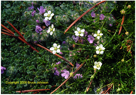
I call "microscopic rainfall." This type of rainfall
is much loved by the dense vegetation of the area (see image from
my backyard).
MICROSCOPIC RAINFALL,
ALSO KNOWN AS SHMIST --
There
are several reasons traditional statistics fail us... A major
one has to do with the character of the rainfall in Olympia, which
is a far different pattern than that occurring in most other regions
of the USA. A good illustration is to compare New Orleans with
Olympia-- both receive lots of rain; in fact, New Orleans receives
about 120% of Olympia's yearly amount. Nevertheless, New Orleans
basks in greatly more sunny days per year, and remarkably fewer
hours of actual rainfall.... Olympia seems to specialize in what
I call "microscopic rainfall." This type of rainfall
is much loved by the dense vegetation of the area (see image from
my backyard).
The Puget Sound area in general rarely gets pounded by large numerical amounts of rain in a single day....typically, rain is light but frequent; often whole days go by under low, gray skies that spit "drizzle," and its even smaller cousin, the pernicious entity that I name "microscopic rain." This is a phenomenon where the air seems to get things wet and keep them wet all day without there ever being sensible raindrops falling. People who wear glasses, like I do, will perceive an annoying bit of tiny mistiness collecting on their lenses. They often will used a more colorful term for this unremitting type of rainfall -- SHMIST, which is short for shitty mist. After a day of Shmist, when the actual, reported weather statistics are checked, such days are often reported as either zero rain, or as a day with a "T" (trace) of rain! Such reportage defies the common sense of people who were trying to work outdoors, whose experience was that it was wet all day.
This moves us to a central failure of the weather collection statistics used nationwide when it comes to capturing rainfall patterns like Olympia's. The official statistics record and rate rainy days in a series of categories that begin with "no rain," then go to "0.01 inches." There are further steps upward, like a day with 0.50 inches or more. The idea is to give people a sense of how often an area is hit with various degrees of heavy rainfall, which undeniably is a serious problem in areas like Texas where hurricane-derived rainfall of 5-10 inches in a single day can cause terrible flooding and loss of life. Olympia might have one day like that every ten years. But Olympia does have many days per year that are "wet, " either with "traces" of rain, or with what I call "microscopic rain," neither of which show up in the typical climate reporting documents officially used across the USA. Maybe this is because a pattern like Olympia's threatens no loss of life, I don't know.
Summer Rainfall and winds. Final aspects of the wet/cool climate of Olympia and the Puget Sound are summer rainfall and summer cool even chilly winds. (image below is just south of Bellingham).....
First, I will
spend a moment dealing with the common happy belief of many residents
of Western Oregon/Western Washington that their summers are dry
and wonderfully sunny. Supporting this belief,
some authorities even assert that the "Mediterranean" climate of California extends
all the way up into Oregon's Willamette Valley, 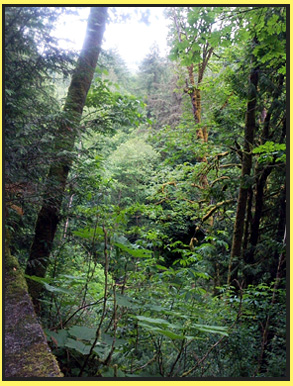 and
a few of them even claim that the PUGET SOUND has a Mediterranean
climate!
and
a few of them even claim that the PUGET SOUND has a Mediterranean
climate!
My own study of the subject leads me to assert that Roseburg, Oregon (latitude 43.2 North) is as far north as a true Mediterranean climate extends reliably each summer..... Certainly, by the time one reaches the shores of the Puget Sound at 47-49 degrees north latitude, it should be impossible to claim that a Mediterranean climate exists unless your definition has become very limited to just "rainy, cloudy winter, followed by fairly dry, fairly sunny summer." This doesn't sit well with me, I guess it's because the term "Mediterranean" brings forth succulent visions of Italian cuisine, a central feature of which is TOMATOES, and not just a few, but an abundance of them, a long growing season, many varieties! In Medford, Oregon, it's easy to grow tomatoes like that. You can do it in Roseburg, too. By the time you get to Eugene, the season's become a bit more limited. And then go another 250 miles north to Puget Sound, yikes, it becomes a tomato grower's nightmare--- you struggle to pull off one single crop of "short season" tomatoes per year! The Puget Sound just isn't like Italy in the summer! Around "The Sound," it's not uncommon for even the height of summer to be afflicted with many consecutive days where Olympia, for example, sits trapped under a dense layer of "cool marine air" (aka "fog" and "low clouds") with chilly west winds off the Pacific, basically no sunshine, highs in only the 60s, and even some drizzle or microscopic rain. For more discussion of Mediterranean, please go to page bottom ..... Also visit my climate page about Medford to sample what a true Mediterranean climate is like.
It is also true that Puget Sound is subject to cold, North-Pacific frontal rainstorms even in mid-summer on a much more consistent basis than in the Portland/Salem area (a good example was early August 2009)..... Finally, there are the cool winds--- during the warmer months, a portion of the longed-for warmth is often stolen away by a windiness that originates over the always-cold waters of Puget Sound, the Strait of Juan de Fuca and the Pacific Ocean. In contrast, as one moves south into Oregon, and especially to the hot towns in Southern Oregon, there is an extremely marked decrease in the average wind speeds during the warmer months (April-October).
SO I PROPOSE NEW TERMINOLOGY TO DESCRIBE THE CLIMATE OF OLYMPIA, including the entire South Sound.... First, definitively throw out calling the climate "Mediterranean." Instead, I propose the more descriptive term, NORTH PACIFIC MARITIME CLIMATE. The extended narrative would read something like-- "North Pacific Maritme Climate with scattered bursts of summer Mediterranean climate July 15 through September 15, and rarely a month before or after these dates, but always scattered and sporadic, and definitely not the steady, reliable summer Mediterranean climate that occurs from about Eugene, Oregon southward into California. In my term, "North Pacific" refers to the perpetually cold, stormy waters of the North Pacific Ocean, while "Maritime" refers to a climate heavily influenced by a cold ocean. Around the South Sound, the "default" climate always tends to reset itself rather quickly to cool, wet and cloudy. The sporadic outbursts of sunny weather with low humidities nearly always occur during times when "Continental" air takes over, bringing in very cold air in the winter, and hot, dry air in the summer.
Poetry about Olympia's Climate: just added, April 2015. Contributed by a friend, click here!
OLYMPIA'S EXTREME CLIMATE. Olympia does have a few surprises, one being that it possesses a consistently more extreme climate than the other major cities of Puget Sound, especially Seattle; although it's paradoxical, Olympia is consistently colder, hotter, has more snow, has more rain, more heavy fog, etc.
Here's a mid-summer example: June 28, 2021, 110 degrees (smashing previous records). August 9, 1981, 104 degrees, August 10, 102 degrees, while Seattle scored 99 and 98 degrees on the same dates.... In terms of long-term averages, however, Olympia's summer's are mild, with the warmest month being July, with an average daily high of only 78 degrees....Nevertheless, Olympia's tendencies toward extremes are often trying...Spring, especially later Spring, can be especially trying--- what happens is what I term the "Heat Wave in a Frozen Bun" effect. An excellent recent example occurred mid-May, 2008--- residents who had been suffering through an endless cloudy, cool spring went from a daily high that was fully 10 degrees BELOW normal on the 13th, to a record-breaking high of 91 degrees on the 17th, which was 26 degrees ABOVE normal, and two days after that highs were back into the low 70s, and cloudy again...and a day after that, folks spent the day shivering in a windy rain with temperatures in the low 50s for much of the day.
Olympia's climatic
yo-yo
is very hard on people and pets, whose bodies rarely have any
extended opportunity to acclimatize to summertime heat levels.....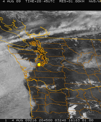 Even in mid-summer,
Olympia tests its residents with this climatic yo-yo-- seldom
do summer heat waves last more than a few days before the winds
turn "on-shore" from the cold Pacific Ocean. Olympia's
location (see satellite photo taken in early August) is at the
small end of a funnel, where coolness, low clouds and rain come
through a low area in the Coast Range and head right into Olympia.
When this happens, suddenly temperatures plummet with chilly winds
and high humidity. It's like Olympia sits upon the juncture between
the climates of Eastern Washington and the Pacific Coast--- when
the winds are on-shore, Olympia is very cloudy, cool and with
high humidity, but when the winds shift to off-shore (blowing
toward the ocean) Olympia can suddenly become very hot, very sunny
and with low humidities.
Even in mid-summer,
Olympia tests its residents with this climatic yo-yo-- seldom
do summer heat waves last more than a few days before the winds
turn "on-shore" from the cold Pacific Ocean. Olympia's
location (see satellite photo taken in early August) is at the
small end of a funnel, where coolness, low clouds and rain come
through a low area in the Coast Range and head right into Olympia.
When this happens, suddenly temperatures plummet with chilly winds
and high humidity. It's like Olympia sits upon the juncture between
the climates of Eastern Washington and the Pacific Coast--- when
the winds are on-shore, Olympia is very cloudy, cool and with
high humidity, but when the winds shift to off-shore (blowing
toward the ocean) Olympia can suddenly become very hot, very sunny
and with low humidities.
**********************************************
Meanwhile, in the record low department, Olympia is consistently surprising for a lowland, west-side-of-the-Cascades city. The city's all-time record lows are a very respectable 7 below zero on January 27, 1972 (seven below zero), and an 8 below zero during the region-wide arctic invasion that occurred right after Christmas 1978 (8 below zero on January 1, 1979, and with a high of only 26). This is surprisingly frigid for a sea-level station located right next to a major body of water like Puget Sound.
During the warmer part of the year, daily record lows never really break out of the 30s; eg. record low for an August 9th was in 1975, a chilling 38 degrees! (Seattle's record low for this date a much milder 47 degrees in 1950)... And August 18, 1973 saw an official 33 degrees, whereas Seattle lowest for this date was again at 47 degrees...... The facts are that Olympia is at risk of hard frost throughout most of the year... It can be tricky deciding when it is safe to transplant those totmato plants to the garden---- in late March (March 24), a record low of 18 was recorded in 1965, and even May in Olympia shows frequent daily record lows in the upper twenties, eg. 28 degrees on May 18, 2003, and again 28 degrees even at the end of May ---May 28, 1966 (whereas the record high for May 28 is a scorching 96 degrees in 1983 -again showing Olympia's ability to be very extreme).
November: Olympia record cold already hitting zero! In the record books, even by November, Olympia has experienced an astonishing record low of 1 below zero TWICE during the month (November 15, 1955, and Thanksgiving Day, 1985). The mid-November 1955 cold wave was not only remarkably cold, but also was remarkably brief, just two days long: Nov. 14 with a low of 3 degrees, and Nov. 15th with a low of 1 below zero.....But Seattle is nearly always warmer than Olympia in these events, for comparison, during the Thanksgiving '85 event Seattle recorded a comparatively mild 10 degrees, and Portland warmer yet at 17 degrees....The Thanksgiving 1985 cold wave produced two consecutive nights of 0 and 1 below zero (22nd and 23rd)..... It is unclear what the mechanisms are that consistently produce the large differences between Seattle and Olympia-- on the face of it, both are sea-level locations right on the shores of a major body of water (Puget Sound). Neither is particularly close to any major range of mountains. Although the "Puget Sound Convergence Zone" is often mentioned in connection with Puget Sound weather and climate, its influence, if any, on Olympia's tendency to be hotter and colder, more rainy and more foggy, has never been explicated to me. On the other hand, the "Rain Shadow" effect of the Olympic mountain range is well-documented as a rain-reducer for areas to the east and northeast of the range, the rain shadow does not explain all of the many climatic differences between Olympia and the Seattle area.
Notes on the paragraph just above-- 1985 in History: the Thanksgiving Arctic Cold Wave of 1985 set extreme cold records that still stand all over Oregon and Washington. In many locations, the November 1985 cold wave set records that came very close to equalling the station's ALL-TIME record low. Such was the case in Olympia, where the all-time record low is only seven degrees colder, an 8 Below zero, set January 1 of 1979.. and a 7 below more recently, right before Christmas, December 23, 1983..... The year 1985 was also notorious region-wide for having major arctic invasions in back-to-back winters---having extreme cold in both January/ February '85 (eg. down to 43 below zero in Oregon's Seneca), and then again ten months later in late November 1985... By December of 1985, people must have been close to believing that a new Ice Age was on its way!
Final Note: Olympia also set its DECEMBER record cold record during the bitter cold wave of December '78-early January '79... On December 30th it was 3 above zero, on Dec. 31st, it hit 5 below zero, establishing Olympia's record coldest for December, and then on January 1st. the mercury hit 8 below, for Olympia's coldest-ever temperature....
Olympia had an earlier severe cold wave in the 1970s. This was in early December of 1972. ... This author personally experienced the December 1972 cold wave, being camped out during it, in Central Oregon's High Desert, where he experienced frost down to 28 below zero F.... the December 1972 Arctic blast in Olympia was quite remarkable. Beginning with a morning low of 5 above zero on Dec. 7th, 1972, Olympia's cold wave went to 3 BELOW zero on Dec. 8th, up to 10 above on the 9th, but sank to 1 BELOW zero on Dec. 10th, finally rising to 11 above zero on Dec. 11th. This is a pretty respectable cold wave for a sea-level and beside-the-water location such as Olympia, WA.
This author rates the December 1972 cold wave as the most severe to hit Oregon/Washington since January, 1950 (in terms of both extreme low records set, and duration of the cold event)......and with global warming apparently firmly in charge, it seems likely that the December 1972 Cold Wave will not be equalled in our lifetimes.
Copyright 2007-2025, by Bruce B. Johnson MA
2007 -- My first summer in the Puget Sound area of Washington State hit me with a long series of ups and downs, mostly disappointments-- a hopeful start in May that fizzled out very badly by summer's end......
Spring in Western Oregon and Washington is a time when seasoned residents are accustomed to renewing their patience, and putting up with a few more months of rain and cloudy skies. They're holding out for the blue skies of summer, that longed-for shirt sleeve weather, and the sunshine that warms the soul until well after 9 pm. each night.*
April 2007: long-term residents of the Pacific Northwest know that April is often just another month in which to hone their patience and stay indoors. April 2007 was cool and cloudy, it only got up to 70 or more on two occasions, and there were clear days only three times, four if you stretched the definition a bit. ..
But in May, as if by Weather God decree, the summer whistle blew precisely on May 15th, and the daytime high roared up to 85 degrees, with everyone joyously sweating, marvelling at the all-day blue skies. Some even began to worry that it was an evil portent of GLOBAL WARMING, that maybe Summer 2007 was going to be one of those new-fangled killing summers, like what had decimated London a couple years ago.
And there seemed
to be proof a couple weeks later when SUMMER CAME EARLY! Again,
the Weather God smiled baitingly, and smack dab on the Labor Day
weekend, true-blue summer weather arrived! For six luscious days
in a row, daytime highs were in the 80s, all the way to 88 on
June 30th. And blue skies ruled, with most of the six days rating
as basically cloudless, lacking even the usual "morning clouds"
that commonly steal about half of each day's sunshine. Little
did they know that this six days was going to be the very best
that Summer 2007 was going to offer them.
Residents had been so astounded by May 15's heat, and especially
by the six straight days of 80s and clear skies from May 29-June
3, that most of them missed the true weather facts of May 2007--
there were only a total of 4 days with highs of 80 or above, and
not very many actual clear days.
Then came June 2007-- after such a great start to summer in May, residents expected great things out of June. But once the May 29-June 3 heat wave was over, there were only four more days that counted as clear in the entire remainder of the month. And overall June was cool, with a meager 5 days having highs of 80 or above, and the highest of those only 84, which happened at the beginning of the month, not the end.
July was when those holding on to hopes of a hot, sunny summer began to get confused and a little worrried. While the month had a total of 12 days with highs of 80 or more, only two of them rose to 90 or above. July 11 skyrocketed to a respectable 99, making it Summer 2007's hottest day, but July's second hottest day was only 91, that recorded the day before the 99 degrees scorcher. The third hottest day trailed far behind, at only 87. (only slightly warmer than May 15th's reading). ..Clear skies with abundant sunshine are a main sign of summer in the Pacific Northwest, but in July 2007 around Puget Sound, while it wasn't bad, but it wasn't great, either. The actual statistics showed only 14 or 15 clear days out of the 31 days, and only about half of those were of the "golden days of summer" category--- clear skies and sun from sunrise to sunset.... Overall, by the end of July it became depressing to hear that the long-term climate records show that July "should be" the hottest and clearest month of the average year. Instead, July 2007 had warm spells coming and going, but never really staying hot for more than a few days. . Puget Sound residents were finding it difficult to spur their bodies into becoming acclimatized for summer heat.
August historically
can often be the rival of July, but in 2007 things were beginning
to look seriously wrong by the 15th, and by month's end it was
clear that Summer 2007 was going Bust. August ended with only
8 days with highs of 80 or above, and the month's hottest was
only 88 degrees! There had been no 90 degree temperatures at all,
a rather rare occurrence for August, even around Puget Sound.
The morning of August 11 had seen a very chilly 43 degrees. People's
garden tomatoes were having a tough time with this kind of thing!
And, worse, August had been marred by repeated periods of rain
with cool temperatures throughout the month, definitely not a
harbinger of summer warmth and September sun to come.
August's poor
showing left the hopeful with only September. Some wished forlornly
that Global Warming might gift the area with a month of late summer.
Those from Oregon were aware that such clear, stable weather in
September is fairly common, and especially so in Southern Oregon.
--- but no gift came. September around Puget Sound began with
over a week of cool, mostly cloudy days that seemed like
Fall. Overall, the month was to have only four clear days, and
spitefully clustered them all into one brief four-day period in
the first half of the month. That single period also contained
the only two days of September when temperatures even got to summer-like
levels of 80 degrees or above.
So summer-lovers
sweated deliciously on Sept.10 and 11, enjoying the clear skies
and highs of 84 and 85, but that was to be "it." The
month of September, our "Last Best Hope," ended with
many days of cold rain, and highs not even reaching 60 degrees.
Summer 2007 had only reached true heat levels of 90 or above on
TWO occasions the entire summer!
The coup de grace to Summer fell on Sept. 30, a day with a bleak high of only 54, and well over an inch of rain! ....Then, just to be sure, came awful October 2 and 3, grim days of heavy rains that caused flooding streets, with highs again in the mid-fifties. October 6th, a day-off-from-work-let's-clean-up-the-yard Saturday, sunk to totally winter-like conditions, with the majority of the daylight hours in the uppper 40s, and a persistent drizzle/mist most of the day that kept everything sopping-wet.
It came down to Indian Summer, the very Last Hope. Just to the south, in Oregon, the so-called "Indian Summer" phenomenom is a common happening, where October often will have a couple long periods of clear or mostly clear days, with warm daytime tempeatures but often cold nights-- in fact, in Eastern Oregon the cold nights can be very cold indeed, with severe, repeated frosts that paint the trees with wonderful fall colors. But even Oregonians were worried this year. Said astronomer Carol Huston, "Well, our gray time of year is descending upon us, earlier than normal it seems. The weather is turning colder, and the rain is already starting to come down. What happened to our Oregon Indian Summer and those beautiful autumn days where the sun is still shining, the wind is starting to blow, the leaves are turning to flame colors on the maples, and the chill in the air is crisp but dry?" (Quoted from the journal of Oregon's largest astronomy club, President Carol Huston in The Rosette Gazette, October 2007).
Finally, on October
13 and 14, for two brief days, Olympia got Indian Summer.
For two days there was abundant sunshine that begain in late morning
after the morning fog burned off, with high temps in the upper
60s, and pleasing fall colors beginning to paint the trees. But
that was short-lived. Winter descended, by October 17, and there
were more snows down to pass levels in the mountains, and daytime
highs in Olympia barely touching 50. For seven long days it was
rainy and cold.
But on October 22 it dried out, and on Oct 23, for one blessed day, a reminder of summer fell upon the city, with partly cloudy skies and a record-setting high of 73 degrees! The heat lasted only one day, but a true Indian Summer had been ushered in.. For the next two weeks Olympia remained uncharacteriscally dry, with cool temperatures, some frosty mornings, partly sunny to mostly cloudy skies, and intense fall colors that locals raved about as the best in many years.
Reviewing Summer 2007, Jim Todd, Planetarium Director at OMSI in Portland stated to a large audience at the Fall meeting of the American Meteorological Society, "We had to cancel all seven of this summer's star parties due to clouds. In 15 years of holding our public star parties, we've NEVER had this happen before."
2007--- TERRIBLE SUMMER. DECENT INDIAN SUMMER. THE END.
So now ensues the endless torture of wondering how many months it will be before another period of 80-degree, clear weather visits the Puget sound area...Those afflicted with Seasonal Affective Disorder will be dismayed to know that, historically, the wait will be long.. If 2007 was any guide, the wait will be until May 15, 2008. For those who can't add that high, that will be a bit over eight months. That is a very long time in anyone's books. Please read our poem about Olympia's climate.
The End Copyright 2010-2025 by Bruce B. Johnson
* Note: Olympia temperatures are reported above.... Seattle's climate is milder overall. During the summer months, Olympia's daily high temeratures are nearly always hotter by 1-5 degrees than Seattle's, and also are usually cooler at night by 2-6 degrees.
** On a related note, it is shocking to see how quickly summertime heat deserts Puget Sound in October, and retreats far to the south... I will illustrate by listing the ALL-TIME RECORD HIGHS for October 10th, with some additional records for October 17-19.
Seattle, record
high for October 10 is 77, and down to only 70 by October 19th.
Olympia, 79 for October 10, sinking to a cool 69 by October 19th.
Portland, Oregon, a comfortably summery 85 on October 10
Salem, Oregon. October 10 has been a bit hot, at 90, and still
warm at 84 on October
19th.
Medford, Oregon (near the California border), 94 on October 10,
and a 97 for October 9th.
(and still 85 on the 19th).
....Thus we see that even in mid-October summertime heat can be be alive and well in Southern Oregon, but around Puget Sound it's long-gone.
Even gloom-hardened long-term residents of the Southern Puget Sound are complaining that it's been the worst excuse for a Spring that they've ever suffered through. Aside from two very brief but very extreme heat waves (one in mid-April and one in mid-May) Spring 2008 has been achingly cold and crushingly gray. Nevertheless, except for June, it has been abnormally dry. ..This writer believes that this pattern is likely related to Global Climate Change phenonmena. In any case, here are the basic statistics, taken from the monthly climate summaries of Sea-Tac Airport, about ten miles south of Seattle. **
March 2008-- 1 clear day, 16 days ranking as partly cloudy-- temps. cool-cold, highest temp of the month only 60 degrees (March 10).
April 2008-- 2 clear days, 15 ranking as partly cloudy -- except for the very brief heat wave, temps. cool-cold. Temps. soared for one day to 79 degrees, but if the brief heat wave is eliminated, otherwise the month's highest was 67 on the 26th. Even more telling, in Olympia there was snowfall on April 18, 19 and 20... all record-setting!
May 2008-- 1 clear day, 14 ranking as partly cloudy -- temps. are again cool-cold, except for one brief heat wave in mid-month where temps soared to 90 degrees for one day. Plants struggle to grow, days like May 13 with a high of only 54 degees and rain make that difficult; everyone trying to grow gardens or commercial growers are having troubles.
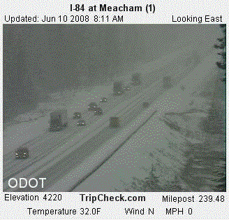
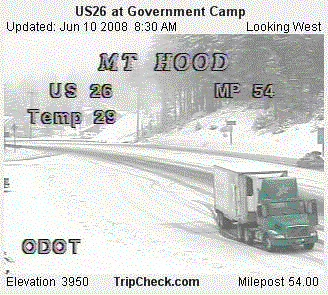
June 1-11-- so far in June there have been zero clear days, zero partly cloudy days. To this point, then, there have been only four clear days for the entire period of March 1 through June 11. June temperatures so far have been very cold for June, with only one daytime high making it out of the 50s. At 3 p.m. on June 11 in Olympia it is just 52 degrees with chilly winds....At Sea-Tac June 5th reached only 54 degrees on a dark, rainy day, and June 9th topped out at only 55 degrees, again on a dark and rainy day. Below are telling road cam images from just over the border in Oregon on the morning of June 10th. Most of the United States on the 10th was suffering under various regional heat waves; meanwhile, in the Oregon/Washington mountains, it was a very wintery scene on June 10th. The first image is from the major InterState route over the Blue Mountains, and the second is from the major route between Portland, Oregon and the whole Central Oregon area; you will note that snowfall is reaching down to winter-like low elevations:
The rest of Summer 2008? Long-range forecasts are predicting generally more of the same for Summer 2008.
** NOTE: data used is from Sea-Tac International Airport. This writer has seen numerous anomalies in the data from Olympia, especially in what appears to be a pattern of inaccuracy in the reporting of sky cloudiness; thus, Sea Tac data is used above....To extrapolate conditions in Olympia, we look to the long-term averages, which show that Olympia is considerably wetter than Sea-Tac (Olympia yearly rainfall is somewhat over 50 inches, where Sea-Tac yearly is somewhat under 40 inches). We also know that Sea-Tac lies on the southern fringe of the Olympia Mountain rain shadow, whereas Olympia is far enough south to be missing the rain shadow effect. Generally speaking, then, Sea-Tac should show an overall pattern of less rainfall than Olympia, and probably also should show somewhat less cloudiness/foginess, and the statistics I've found about regional foginess seem to support this conclusion.
2008 -- By August 25th., even long-term residents of the Puget Sound area were heard complaining that Summer 2008 had turned out to be a very disappointing excuse for a summer.
August historically can often be the rival of July-- dry, with lots of heat, and lots of sunshine. But in 2008 things were beginning to look seriously wrong by the 18th, a grim day where SeaTac had a high of only 64, accompanied by rain. By August 25th, it was clear that Summer 2008 was going Bust, just like Summer 2007 had.... On August 25th, the predicted high for Seattle was only 64 degrees, with clouds and showers.
August 2008 had briefly startled everyone by having the Summer's only real Heat Wave in mid-month. But that had vanished into banks of cool clouds and rains on Aug. 18th....By August 25th, there had been only FIVE days rated as "Clear" by the SeaTac weathermen, and the temperature had reached above 80 degrees on only nine days...August's hottest was only 90 at Sea Tac and 93 at Olympia, which were only a bit less than the year's highest at both SeaTac and Olympia (92 at SeaTac and 94 at Olympia, both recorded on June 29th)..... August also sported plentiful rain, coming on many days, and there were of course several more where rain threatened, curtailing the picniking and swimming plans of summer-starved residents.. .. If one defines a "Heat Wave" as any day where the overall temperature of the day is three or more degrees above normal, the longest continuous heat wave for August was only five days long in Tacoma, and five also in Olympia. This short heat wave was also the entire summer's longest heat wave! (unless something truly record-setting happens in September)..... Curiously, despite the small stature of August's heat wave, you would never have known it after listening to the local tv weathermen launching warnings about heat stroke and all manner of other dire heat alerts. I guess this comes from the sad fact that there was so little real heat this summer that residents never really had a chance to get their bodies acclimatized to summertime heat levels!.
Spring 2008 Heat Wave... and a final note that amazes in this topsy-turvy year-- 2008's longest and hottest heat wave was actually in the Spring, where the period of May 14-19 had some truly serious, record-setting heat, rising as high as 91 in Olympia and 90 at SeaTac. But instead of being a portent of a sizzling summer to come, the Spring heat wave was to be Puget Sound's best attempt at a real summer for 2008!
Late September 2008 Update. Well, something highly unusual did in fact occur during the opening half of September! SUMMER FINALLY CAME TO THE PUGET SOUND! The heat seemed fiendishly contrived to mock the thousands of children returning to school because it began just a couple days after most of them returned to classes after their "summer" breaks! In Tacoma, at SeaTac, the thermometer jumped to a nice 76 degrees on the 7th under partly cloudy skies, then went up to 78 on the 8th under skies rated as "clear." Temperatures stayed in the 70s under mostly sunny skies up until the 16th, which had the warmest reading, that being a summery 80. Although the period did not qualify as a "heat wave," it did in fact give the area Summer 2008's longest period of continuous days rated as "clear," that being nine consecutive days, from Sept. 8-16....However, it all ended with a big "Rush into Fall"** on the 17th, when temperatures cooled and skies became partly cloudy. By the 20th, the high reached only 58 degrees under cloudy skies with heavy rain, and it's stayed cool and showery right up to this writing (Sept. 26th)... of note here is that by Sept. 26th, Sea-Tac's potential for any real heat is basically gone-- the record high for Sept. 26th being only 78 degrees (recorded in 2006). (** some climatologists have identified a Puget Sound pattern where the transition from the cloudy/cool/wet conditions of Spring into dry/somewhat sunny/warmer conditions of Summer occurs very slowly and with frequent reversals -- WHEREAS, the transition from Summer into the cloudy/cool/cold/rainy conditions of Fall occurs very fast and seldom has reversals once it gets started. This can be depressing!)
Wikipedia defines
Mediterranean climate: "The climate is characterized by hot, dry
summers and cool, wet winters. For example, the city of Perth,
Australia, in the southern hemisphere, winter months of June-August,
experiences 450 mm (17.7 inches) of rainfall and an average daily
minimum of 8°C (46°F). Meanwhile during the summer months
of December to February the city only averages 32mm (1.3 inches).[1]"occur.
Woodland: Oak woodlands are characteristic of the Mediterranean
Basin and in California, along with pine woodlands and, in California,
walnut woodlands." In Oregon, the Medford area (42.2 degreesn N. latitude)
in Southern Oregon is a very good example of the Mediterranean
climate type.
More from Wikipedia: "Savanna and grassland: The California
Central Valley grasslands are the largest Mediterranean grassland
eco-region, although these grasslands have mostly been converted
to agriculture...Fire, both natural and human-caused, has played
a large role in shaping the ecology of Mediterranean eco-regions.
The hot, dry summers make much of the region prone to fires, and
lightning-caused fires occur with some frequency. Many of the
plants are pyrophytes, or fire-loving, adapted or even depending
on fire for reproduction, recycling of nutrients, and the removal
of dead or senescent vegetation. In both the Australian and Californian
Mediterranean-climate eco-regions, native peoples used fire extensively
to clear brush and trees, making way for the grasses and herbaceous
vegetation that supported game animals and useful plants. The
plant communities in these areas adapted to the frequent human-caused
fires, and pyrophyte species grew more..."
**************************************************************************************************************************
Olympia Poem. This applies to all of the Puget Sound!
"It rained and it rained,
The average fall was well maintained.
And when the trails were simply bogs,
It started raining cats and dogs.
After a drought of half an hour,
We had a most refreshing shower.
And then the most curious thing of all,
A gentle rain began to fall.
Next day was fairly dry,
Save the deluge from the sky.
Which wetted the party to the skin,
And after that, the rain set in."
Contributed by an anonymous friend at a recent party in Olympia!
****************************************************************************************************************************