On this page I present the work of Michel Hersen, a friend of mine with a sense of vision that swiftly brings me to that sense of magic in Nature. Michel has impressive academic credentials in Fine Arts, and that training is everywhere evident in the color and composition of his work. He and I have discussed offering his work for sale here; if interested, please contact me at: (jupiterman47@gmail.com). Here is the address of his online gallery: http://photographybymichel.squarespace.com/
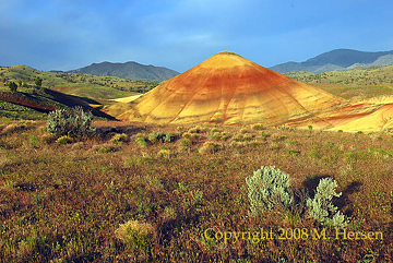
The Painted Hills lie deep in the canyons of Wheeler County, one of Oregon's most remote and least-settled areas. The climate here is arid, a unique blend of the harsh High Desert climate with the warmer, lowland climate found within the Eastern Columbia Gorge. On August 23, 2017, the path of the Solar Eclipse totality passed right through the Painted Hills, leaving some of my friends there in awe.
The 3,132 acres of the Painted Hills are politically a part of the John Day Fossil Beds National Monument, which was established in 1975. All is not barren at the Painted Hills, and the visitor will find a landscaped area providing restrooms, water, shaded picnic tables, and exhibits.
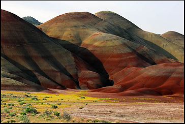
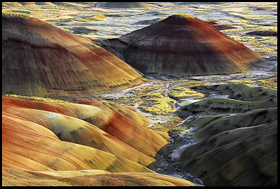
Where are the Painted Hills? In geographic terms, the Hills lie at an elevation of 2,000 feet along Bridge Creek. Go down Bridge Creek only 7 miles and it joins the region's biggest river, the John Day River. Go down the John Day from this point and it's a 135 mile float to the junction with the mighty Columbia River.... The Painted Hills lie nearly 80 miles east of the Cascade Crest at Mt. Jefferson, and thus are very much within the overall rain shadow effect of the Cascades and in what would generally be called "Eastern Oregon." The Hills also lie on the northeastern corner of the Ochoco Mountains, which rise up to nearly 7,000 feet just 13 air miles away, hence providing the Hills a secondary rain shadow effect. As the crow flies, the Hills are about 72 miles south of the Columbia River at Arlington, Oregon on I-84.... The Hills are about 70 air miles to the northeast of Bend, Oregon. The nearest city of any size is Prineville, in its valley on the opposite side of the Ochoco Mountains. In climatic terms, one of Oregon's hottest summer climates is found just 25 air miles east along the John Day River at Spray and Kimberly, which are renowned for their excellent fruit orchards. Kimberly houses the Monument headquarters. In the picture below, yellow flowers paint the hills and outwash plains. There are several common yellow flowers in the Monument, and my bet is that this one is the John Day chaenactus, which blooms April-June and loves barren clay soils derived from (volcanic) tuffs.