Most people get to OSP via the "standard" route that takes them past the Ochoco Ranger Station and along the south side of Big Summit Prarie. But there is a great alternate route to OSP that the more enterprising can take!
You'll drive to Prineville as usual, and then eastward on Highway 26, again, as usual... But instead of turning right to go to Ochoco Ranger Station, you continue on Hwy 26..... You cross over the Ochoco Summit, and go down the east side of the Ochocos into a deep canyon. Soon you've left all the big trees behind and are looking at sagebrush and juniper country. Likely it has turned hot. These canyons in this part of Oregon are some of the hottest places in the whole State of Oregon during the summer months! (Click here for climate details-- note that Spray is just a bit northeast of Mitchell, and also know that Prineville is the co-holder of Oregon's official record highest-ever temperature, that being 119 degrees.)
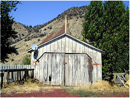
Down at the very bottom of the deep canyon
sits the tiny town of Mitchell. It's on Highway 26, some 47 miles
east of Prineville, elevation only 2760 feet. The picture of the
weathered garage typifies the town, which bills itself as the
gateway to the Painted Hills National Monument (click
for my section on the Painted HIlls)...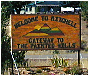 Many
years ago, in 1976, the town briefly bustled because it was right
on the route of Bike
Centennial '76, and cross-country bicyclists
found it and its bed and breafast places to be a fine stop-over.
The garage picture also contains a silent "sign of the times,"
where this rustic, remote garage has become equipped with a modern
satellite TV antenna! (and this was in 2001)
Many
years ago, in 1976, the town briefly bustled because it was right
on the route of Bike
Centennial '76, and cross-country bicyclists
found it and its bed and breafast places to be a fine stop-over.
The garage picture also contains a silent "sign of the times,"
where this rustic, remote garage has become equipped with a modern
satellite TV antenna! (and this was in 2001)
Another interesting and sobering feature of this deep dry canyon location is a climatic feature luckily not shared by our OSP site. One thinks of Arizona and Texas as places where you must be wary of FLASH FLOODS.... But these deep and steep desert canyons of Eastern Oregon can occasionally suffer serious flash floods. I don't recall the exact year, but a very bad flash flood struck Mitchell sometime in the 70s, wiping out many parts of the town and taking out a big chunk of Highway 26 itself, leading to a huge road-rebuilding project to avoid such a calamity in the future. I think Bridge Creek was the main source of the flood waters.
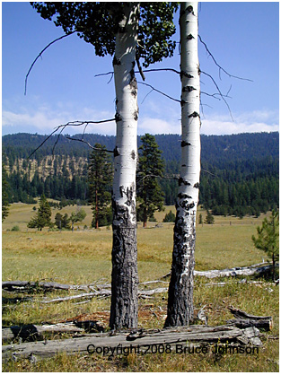 To
get up to Big Summit Prarie from Mitchell, you leave town on County
Road 8, heading south on good gravel road. As the road ascends
into the Ochoco Mountains from Mitchell, it becomes USFS Road
22. By the time you've climbed to about 4,000 feet, you're back
in a dry but very pretty forested zone with ponderosa pines, open
grassy meadows and scattered aspen trees. Look for wildlife, and
you may well spot Elk.
To
get up to Big Summit Prarie from Mitchell, you leave town on County
Road 8, heading south on good gravel road. As the road ascends
into the Ochoco Mountains from Mitchell, it becomes USFS Road
22. By the time you've climbed to about 4,000 feet, you're back
in a dry but very pretty forested zone with ponderosa pines, open
grassy meadows and scattered aspen trees. Look for wildlife, and
you may well spot Elk.
CHIEF PAULINA:
Near the summit, imagine yourself back in time, all the way back to 1867. That's when the notorious Chief Paulina of the Northern Piute was killed just to the east; as the story goes, he was eating breakfast and was alone. The date was April 25. The 33 yr. old had had a very successful "career" of raiding and terrorizing settlers since about 1859. He had been extremely elusive and able to elude the many soldiers and others attempting to bring him down. Many place names in Central Oregon are named after him, eg; Paulina Lake and the town of Paulina.
Once you get up to the summit, where you cross over a divide and descend onto the east side of Big Summit Prarie, the road becomes significantly worse, but still passable to the average automobile.The sidetrip to the Cold Springs Range Station area is quite interesting, and not only has wonderful fresh water source, but loads of aspen trees. Once I even stalked a huge bird in the dense wetlands. I suspect it was some kind of crane or heron...When you hit the paved road again at the Crooked River cement bridge you'll be about 26 miles from Mitchell. Now, turn right (west) and go about 100 yards, then take your normal turn up onto the dirt road to Indian Trail Springs and OSP!