Southern Oregon's
Mountains and Cities
including Crater Lake
and Diamond
Peak
Southern Oregon's
mountains are comprised of a region extending south from Willamette
Pass to the Oregon -California border, and westward to the Pacific
Ocean. Peaks exceeding 8,000 Ft. are numerous, including north
to south, Diamond Peak, Tipsoo, Howlock Mtn, Mt. Bailey, Mt Thielson,
Mt Scott, Mt McLoughlin, Pelican Butte, Yamsay Mtn, Gearhart Mtn,and
Aspen Butte...Going westward along the Siskiyou Mountains there
are several peaks over 7,000 ft, such as Mt. Ashland, Dutchmans
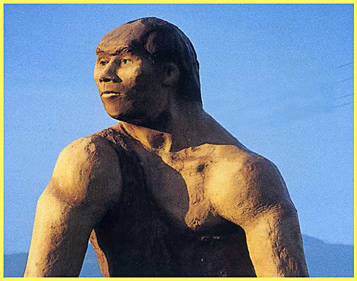
Peak and Greyback Mountain.... A Booster Club in Grants Pass named
themselves "The
Cavemen" and made
this region notorious as the haunt of a clan of antics-loving
Neanderthals, who greeted the likes of President John F. Kennedy
when he visited the area in the early 1960s. Image at page top
is my scan of an old postcard, showing the giant "caveman"
statue that has greeted visitors to Grants Pass for many decades.
Southern Oregon
Navigation
1. Click here
to visit Southern Oregon's Siskiyou
Mountains, the Rogue River Valley, and Mt Ashland Ski Area.
Includes link to Oregon Caves National
Monument near Grants Pass and Cave Junction.
2.
Click
here to visit one of Oregon's
original Wilderness Areas, the Mountain
Lakes Wilderness Area, near the well-known resort areas of Lake
of the Woods and Harriman Lodge.
3. Click here to visit Mt. McLoughlin,
the highest peak in the Southern Oregon Cascades, nearly 10,000
ft high... (older
maps will show the mountain named "Mt. Pitt"). See a
history of the fire lookout buildings on the summit of McLoughlin
1917 to the present.
4. Click here to
visit Lake of the Woods Resort area, at the foot of Mt.
McLoughlin and Brown Mountain.
5. Click here to visit Klamath
Falls, arguably the
highest elevation and sunniest full-fledged city in Oregon.
6. Diamond Peak and Willamette
Pass area, see below
Diamond
Peak, 8,744----Just south of Willamette Pass, and 80
miles north of Mt. McLoughlin, Diamond Peak soars; but, amazingly,
it is little known to most Oregonians. The peak is the heart of
the smallish, 36,637 acre Diamond Peak Wilderness Area, established
2/05/1957. Part of the Wilderness lies in the Willamette Nat'l
Forest, and part in the Deschutes Nat'l Forest. GLOBAL WARMING: in 1972
I climbed Diamond Peak in June and was amazed to note a small
residual glacier on the north side of the main summit. That picture
is found here: Glacier
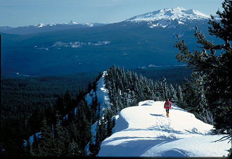
The left image, taken from 7,144
ft. Fuji Mountain on Bunchgrass Ridge, shows Doug Newman, one of the
founding members of the University of Oregon's famed Eugene
Outdoor Program.(the program's
modern name is University of Oregon Outdoor Program (UOOP), aka
Outdoor Pursuits Progam (OPP), and in 1998 "Sports Afield"
magazine awarded its top honor to the OPP as best overall outdoor
program among the USA's colleges and universities; I had the honor
to be one of the original trip leaders during its formative years).
.. In the image above, one can spot Diamond Peak, Mt Thielson
and the rim of Crater Lake.... Willamette Pass and Willamette
Pass Ski Area lie between the hiker and Diamond Peak.....
Doug Newman published
a book titled FINDING FIRE in 1982 about
Oregon's Lane County Lookouts; it's very interesting. It can be
purchased from the Lane County Historical Society in Eugene; I'm
seen on pg. 18, the last guy on the left in the 1968 picture of
the Fuji Mtn. lookout (burned by the USFS in 1972).ka UOOP...EMU Outdoor Program
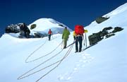
The right image (the small one)
shows a team of climbers from Eugene YMCA Wilderness Camp approaching
Diamond Peak's summit...
Please
click on Image to see
a far more exciting version!
Author's disclaimer: Many who
have hiked the Diamond Peak region of the Oregon Cascades proclaim
it to be the Scourge of the Cascades, buzzing furiously with billions
of tiny black mosquitos and other stinging critters all summer
long due to its continous heavy forest cover and multitudes of
small lakes and ponds. Visit in October, or ski in when the little
guys are buried under ten feet of snow!
Aspen Cabin
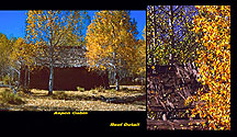
---In
Southern Oregon, the region on the eastern (dry) side of the Cascades
is resplendent with blazing aspens in October. This ruined
cabin was found on a peaceful slumberous day many years ago, west
of Upper Klamath Lake.

Back to
OregonPhotos Main Page and the E-Mailer

Revised
2/3/2024
 ....
.... click
click