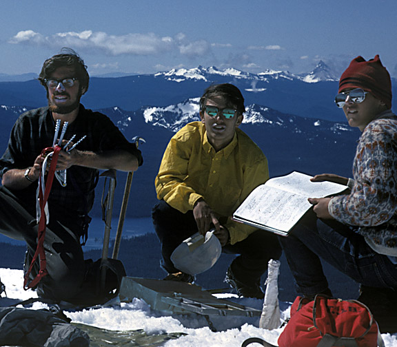
We left the trail around the east flank of Diamond Peak in mid-afternoon. It was becoming pointless anyway, since the late May snowpack was so extensive by the time we reached 6,000 ft. that following the trail was nearly impossible. We struck off straight uphill through the dense fir forests in the soft snow, sinking at times nearly to our crotches. But by nightfall we'd made it to 7,200 on the SE flank, the trees were mostly below us, and there was a great sense of open space all around us. That night it rained, then froze, and we weren't all that comfortable under our plastic tarp suspended between two big Mountain Hemlocks. Dawn came very early, so close to Summer Solstice, and the Sun's very first rays began to warm our camp while the entire lower world was still in chilly shadow. We climbed into the brilliance of fresh snow upon the treeless upper mountain. We amazed ourselves by setting off two small avalanches as we ascended the SE Bowl. By 8 a.m. we scrambled onto the summit ridge, eased past a big, dark gendarme (see link to pic), and strode onto the broad expanse of the extinct volacano's 8,744 ft. summit.
Our goal, to find the summit register.
Luckily, there was a small weatherbeaten post sticking up through
the deep snow near what we judged to be the highest point, and
 a little
digging with our ice axes soon struck the weathered gray metal
of a typical mountaineer's summit register (see pic above). Inside,
the journal soon revealed that we were the first up the mountain
this climbing season-- or at least the first able to locate the
register!
a little
digging with our ice axes soon struck the weathered gray metal
of a typical mountaineer's summit register (see pic above). Inside,
the journal soon revealed that we were the first up the mountain
this climbing season-- or at least the first able to locate the
register!
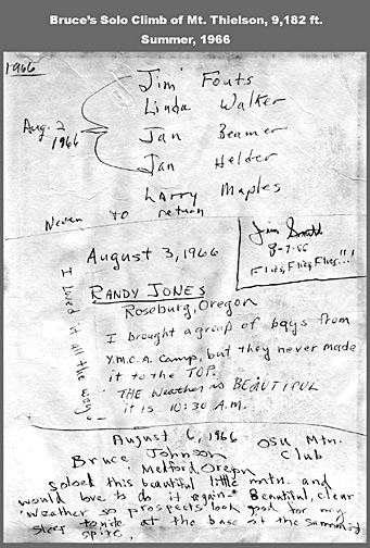
These priceless little books are periodically collected and brought down to civilization to be archived at Mazamas headquarters* in Portland, so beware, what you write up there during the haze of fatigue and altitude may come back to haunt you! * The big white building is located at 43rd and Stark in SE Portland. The records are stored along with other endurinjg treasures in a very large climate-controlled room, a part of the main Mazamas Library. Access would be upon special request. When I searched in the Mt. Thielson records, I found my best friend's words from the register up on Mt. Thielson in 1964 and '65. What a memory-trip that was! Later, my friend at the Mazamas Library found my own entry from summer 1966 (see image to left; my entry is on the lower part of the page)....Mt. Thielson can be seen in the picture at the top of the page-- it's the pointy, very prominent peak on the right side of the picture.
 Geocaching: This new sport seems to me to be a high-tech
activity that draws its inspiration from the grand old tradition
of mountaintop summit registers. You fight, you struggle, you
endure bad weather and bugs for the prize--- a link to other similar
travellers of the out-of-doors, both past and future. You read
of their journey, you enjoy the surprises of their little leavings,
and you carefully compose a few lines for future readers to hear
of your journey. At the time, it probably never occurs to you
that this one day in Time may be the only time in your Life that
you stand here with this opportunity to say something for others
about this adventure you have had this day.
Geocaching: This new sport seems to me to be a high-tech
activity that draws its inspiration from the grand old tradition
of mountaintop summit registers. You fight, you struggle, you
endure bad weather and bugs for the prize--- a link to other similar
travellers of the out-of-doors, both past and future. You read
of their journey, you enjoy the surprises of their little leavings,
and you carefully compose a few lines for future readers to hear
of your journey. At the time, it probably never occurs to you
that this one day in Time may be the only time in your Life that
you stand here with this opportunity to say something for others
about this adventure you have had this day.
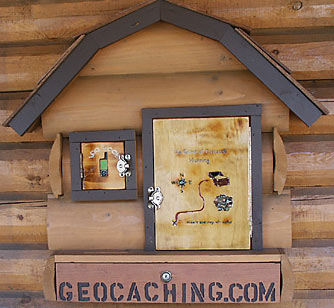
The geocache site shown above is on the Northern Oregon Coast. It's attached to the side of a store just outside the entrance to Fort Stevens State Park.. I found the setting and facilities to be very pleasing. A smart place to put this Geocache!