 Headline:
A major destination resort is (was) slated for Mt. Hood's northeast
side
Headline:
A major destination resort is (was) slated for Mt. Hood's northeast
sideHeadline:
A major destination resort is (was) slated for Mt. Hood's northeast
side
A much more optimistic Headline from 2009-- President Obama signs the Omnibus Wilderness Bill and adds thousands of acres to the Mt. Hood Wilderness and make inclusion of disputed area near Cooper Spur more likely! (skip to more recent information)
Prelude: OregonPhotos strives to be an educational resource promoting knowledge about, and appreciation of, the wilder, more remote natural areas of Oregon...However, on occasion, as owner of OregonPhotos, I feel the need to make a statement that some might view as political or environmental. And in reference to the bubbling brew of big-time development that is sneaking up on Mt. Hood, well, I just have to stand up and speak.
The planned resort development will (would have affected) affect Cloud Cap Inn/Cooper Spur Inn/Cooper Spur Ski Area/ Mountain Shadow Estates/ Parkdale/ the Upper Hood River Valley--- in fact, the entire county of Hood River will be impacted.
There are (were) major plans well underway between Mt. Hood Meadows Ski Corporation, Hood River County, and probably other monied interests, for the decimation of Mt. Hood's "quiet side" by a major destination resort. Make no doubt about it, multi-million dollar land exchanges have already occurred, Cooper Spur Ski Area has already been bought up, etc. This resort complex is going to happen as planned unless---- well, unless concerned people with other values work very hard to preserve the more primitive character of this portion of Mt. Hood.
Although I live in the Portland area, my perspective at OregonPhotos is always Oregon, the State taken as a whole, and in this perspective Mt. Hood is not just Portland's private playground, rather it reigns in a unique status as Oregon's highest and most glaciated mountain (11 active glaciers, a dormant volcano, still with smoking sulpher hot areas on the upper mountain, and host of small earthquakes in its vicinity every year). A treasure for all the residents of the State.
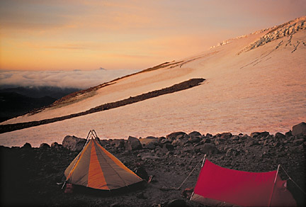
Unlike the balance of Oregon's beautiful mountains, Mt. Hood is unlucky to find itself in the very backyard of Oregon's largest and most vital metropolitan area. Major all-weather paved roads provide exceptionally easy access to the south, SW, SE, E, and NE sides, only the north, NW and west sides are less accessible. The peak itself is the most climbed major snow peak in the United States, and boasts one of the highest accident rates of any peak on Planet Earth. (insert pic of Mtn's south side taken by me a month ago)
Wy'East is the peak's Indian name, rich in lore, but always in Hood's history there has been a dichotomy between, on the one hand, the clear perception that Hood is a treasure deserving major protection, eg. National Park status such as the Seattle area's Mt. Rainier enjoys, and the other hand, the clear reality that this is a DEVELOPED mountain---even since the 1890s hotels and lodges have been creeping up the mountain all the way to timberline at 6000 feet and above.. Heck, if the Great Depression had not intervened in development schemes of the 20's, there would be a gigantic aerial tram running up the NE side of Hood, all the way to the summit, and the current small US Forest Service Wilderness Area might never have been established.
So Mt. Hood has a history of being "USED," although
there is also a long history of folks interested in its perservation
in a natural state-- it was made a Forest Service Primitive Area
in 1931, then was formally designated as one of Oregon's earliest
Wilderness Areas on 6/27/1940, and expanded from its initial tiny
14,160 acres in 1964 to its present (still small) 47,100 acres
(increased to 67,320 acres by Obama's wilderness efforts in 2009).
The size, taken in context of the major human developments high
on the peak, is still too small in size to provide any very meaningful
buffer to major resort developments (the Wilderness comprises
only 4% of the Mt. Hood National Forest)... When you hike or climb
in the mountain's alpine zone, especially on the highly developed
South and East sides, your eyes and ears easily perceive that
the Wilderness boundary is too limited, the miles too few to block
the sights, smells and odors of major ski runs, traffic jams,
night ski area lighting, and soon, we fear, the "scenery"
will include views of nearby trophy homes. Already, wilderness
solitude is not easy to find as you circle the Mountain along
the 38 miles of the Timberline Trail, where camping areas are
already limited due to overuse syndromes and Forest Service closures.
(skip to page bottom for some more
optimistic thoughts post-Obama's signing of the 2009 Omnibus Wilderness
Bill)
In a bad dream I see into fifty years from now: the Mt. Hood Wilderness has become like Portland's famous Forest Park. Yes, you can hike a long way, and see lots of trees, but, no, there isn't any real wildlife, and, you'd have to be nearly deaf not to hear the constant roar of urban Portland behind every tree. Development in the next 50 years will threaten to overwhelm the tiny Mt. Hood wilderness, driving out the wildnerness values that remain on Oregon's highest peak. Too Bad.
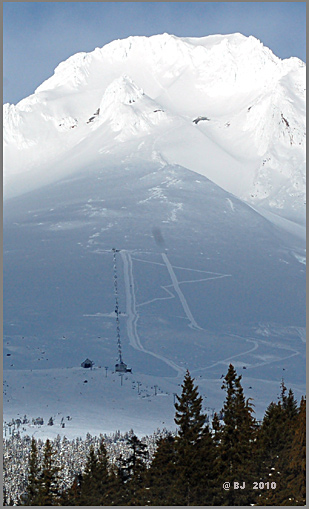
The Mountain's NE side, the target of major well-planned and well-financed development, is also unfortunately quite unique-it is very unlike the west or NW sides, being higher, much drier, and historically the seat and center of a tradition of technical climbers, low-budget skiers and backcountry enthusiasts. There is only one significant access road to this zone (FS road S12), and its nature will be terribly altered if the developers succeed. In 2003, you can still drive up the mountain and experience a pleasant and gradual transition into wildness and the mountain's timberline delights at road's end at 6,000 feet.... But after development of the new Resort, your journey will become like driving a gauntlet through crowded city highways, then winding through the eliteness of a place like Sunriver, finally to reach a brief transition of a few miles of gravel road spewing you out to what little is left of Mt. Hood's "wilderness."
Here is an example of the class
of NE-side attractions which will be lost: Cooper Spur Ski Area.
Already it has been sold, its fate is probably sealed, but here
is a Requiem to "old-fashioned family skiing." Can you
believe all day lift tickets were only $9 just a couple years
ago?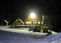 And
you could buy into two days of skiing with full lessons for about
$35.
And
you could buy into two days of skiing with full lessons for about
$35.
The cozy day lodge and the Area's one page, non-glossy brochure blatantly billed the Area as "family" and "low cost." This was a place unlike any other still in existence on Mt. Hood, an unpretentious place welcoming to mountain visitors with kids, old-fashioned gear, and slim wallets.
 My family and I last skied there in December of 2001; we sledded
a bit, then we rode the rope tow, and finally put on our climbing
skins on our cross-country skiis and walked up the edge of the
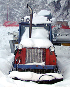
ski slopes up toward the top of the T-bar lift. Along the way,
we passed an abandoned slope groomer/plow machine which added
a mellow, old-timey feel to our exploration. As evening fell,
we were beckoned to the lodge for hot chocolate before driving
back to the City.
My family and I last skied there in December of 2001; we sledded
a bit, then we rode the rope tow, and finally put on our climbing
skins on our cross-country skiis and walked up the edge of the
ski slopes up toward the top of the T-bar lift. Along the way,
we passed an abandoned slope groomer/plow machine which added
a mellow, old-timey feel to our exploration. As evening fell,
we were beckoned to the lodge for hot chocolate before driving
back to the City.
So develop the heck out of all
the fringes of Hood's alpine backcountry paradise, take away its
one and only and last inexpensive family-oriented ski area, add
traffic jams of major proportions to this last refuge of Mt. Hood
wilderness lovers, turn the incomparable rural agrarian beauty
of the Upper Hood River Valley into yet another trophy home development
for the wealthy while Oregon as a whole continues to suffer years
of unemployment and economic woes. Oh, and force out the farmers,
orchardists and retirees who love this quiet corner of Oregon---
and all the time, you powererful, deny you are doing it, deny
you are collaborating on long-range plans that you will not cease,
deny that you are working in secret behind closed doors with minimal
citizen
involvement….. it is the American Way, it is those with Big
Money vs. those with other values.
As was so accurately noted by
outdoor writers Ira Spring and Harvey Manning in their 1974 classic
"Wilderness Trails Northwest," the challenges to Mt.
Hood will only worsen with each passing year, so listen to the
authors' words from 30 years ago:
"…The lovely pyramid of the glacier-white volcano is
a landmark throughout a great expanse of two states. Little of
the peak is in the very small wilderness, which mainly is limited
to rock and ice. Forested ridges are being logged and meadows
of the south slope are commercialized by ski lifts and snowmobiles
that climb as high as 10,000 feet. Just an hour's drive from Portland,
whose skyline it dominates, the mountain is mobbed the year around…"
(pg. 124).
So shall we proceed with the mobbing of the mountain's NE side?
-- Bruce B. Johnson, owner, OregonPhotos.com, Hood lover who has summited the Mountain six times
The signing of the 2009 Bill* not only increased the size of the Mt. Hood Wilderness, it also added considerably to the overall Wilderness opportunities all around Mt. Hood. It also increased the likelihood that the long-disputed LAND TRADE around Crystal Springs Watershed in the Cooper Spur area would be finalized. The Swap would be 770 acres for 120 acres. That's 770 acres on Cooper Spur going into Wilderness, and the Portland owned Mt. Hood Meadows LLC receiving 120 acres of prime land in Government Camp. Forest Service estimates, however, say finalization will probably take 2-5 years. (* Public Law 111-11)
Let's go through a list of Oregon Wilderness areas now surrounding Mt. Hood. From north to south, we begin with the Mark O. Hatfield Wilderness, paralleling the Columbia River Gorge on the Oregon side of the River. Then there is the Salmon-Huckleberry Wildeness, nearly adjoining the Mt. Hood Wilderness on its southwestern side. Just to the south of Mt. Hood lies the small (2870 acres) but much-needed Lower White River Wilderness. Just to the east of the peak and across the deep valley of the Hood River rises one of my personal favorite areas, the Badger Creek Wilderness, topped by 6500 foot Lookout Mountain. Further to the south and west of Mt. Hood lie others: the Roaring River Wilderness, the Opal Creek Wilderness, the Clackamas Wilderness, the Bull of the Woods Wilderness, and the Table Rock Wilderness (a BLM wilderness, another of my personal favorites, click this link).....And of course we cannot neglect to mention the mighty Mount Jefferson Wilderness because it contains the supremely prominent peak that the streams of visitors to Mount Hood constantly see in the distance (click for my pages on Mt. Jeff).
End