Portland's Paralyzing
Ice Storm 2004, Worst in about seven years
 The
Storm began to unfold with an unexpected heavy snow storm on the
morning of New Years Day, which was Thursday, January 1st. This
snowstorm, however, was spotty, and mostly affected outlying areas
to the south of Portland city center, such as Canby and Aurora.
The
Storm began to unfold with an unexpected heavy snow storm on the
morning of New Years Day, which was Thursday, January 1st. This
snowstorm, however, was spotty, and mostly affected outlying areas
to the south of Portland city center, such as Canby and Aurora.
In places like Canby, it began
to snow around daybreak, and soon 4-6 inches piled up. It was
the drier, lighter snow that is so enjoyable, and so unusual in
the damp martime climate of the Portland area.
The picture on the left was published
in the March/April 2005 national magazine named "Weatherwise," page 32. This glossy magazine is an excellent
resource for those with a serious weather interest, but in most
areas you won't find it on news stands, and you will need to get
it by subscription. Click here
to find out more about this truly excellent magazine.
Temperatures stayed a bit subnormal
for the next 3-4 days, and then temperatures dived. On both the
5th and 6th highs in Portland at PDX reached only 24 degrees,
and with brutal east winds screaming out of the Columbia Gorge...Both
of these days broke the old records for "low maximum temperature"
for the date by 4 to 5 degrees.
On the 6th, all the intoxicating
snow fun ended when warm air aloft began to override the cold
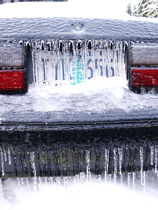
arctic air.. Then a major FREEZING RAIN event turned the fun into
danger that lasted for 3 to 4 long, long days and nights.
Both major freeways into and out
of the Portland area were periodically CLOSED, as was MAX, Portland's
famous light rail system.
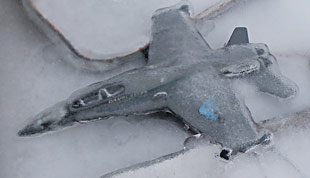 Even PDX (Portland International Airport) was CLOSED, the airport
setting an unenviable record for itself with some 2 1/2 days of
no service, with thousands of stranded passengers and dozens of
severely iced-up jet planes!
Even PDX (Portland International Airport) was CLOSED, the airport
setting an unenviable record for itself with some 2 1/2 days of
no service, with thousands of stranded passengers and dozens of
severely iced-up jet planes!
Area Schools were closed for 3-5
days, as parents and children struggled to even walk on the skating-rink-like
surfaces hemming them in on every side. Power outages seemed to
go on endlessly, affecting people all the way down the Willamette
Valley into Corvallis and Salem. Even after temperatures recovered
to above freezing, some customers, especially some in rural outlying
areas, still were without power for 2-4 days. With the thaw, other
bad things happened, for instance, when the roof on a major department
store caved in on Friday in NE Portland!
The End: On Friday the 9th, even the eastern areas of Portland
near Troutdale and the mouth of the Columbia River Gorge were
finally above freezing and the huge accumulations of ice were
beginning to slowly dissolve into a big mess. Portland's bout
of ice and snow had lasted nine long days.
Weather events such as the 2004
ice storm can be devastating for people and businesses. Forecasting
these events has become an important job of meteorologists today.
Modern computer programs and CMMS
Software are important in keeping track of storms. Predicting
the progress of potentially hazardous storms has kept computer
programmers busy. With the history of computer
technology changing daily, keeping pace with these changes
can be difficult. Hopefully, weather forecasters will help in
predicting and alerting us about future storms, so that we will
be better prepared.
WWW.OREGONPHOTOS.COM

Page last reviewed May 20, 2020