|
Location |
Portland, elev. 100 ft., Oregon's largest
city |
Seneca, 4,700 ft., holder of Oregon's
all-time record coldest |
Joseph, elev., 3,800 ft., legendary
home of the Nez Perce Indians in far NE Oregon |
|
Feb. 15th, the arctic air arrives in
the very early morning hours with powerful, gusty N to NE winds. |
46 high temp.
26 low temp. |
23 high temp.
13 low temp. |
28 high temp.
14 low temp. |
|
Feb. 16th, the cold wave air begins
to settle and stagnate in Oregon's coldest locations |
45 high temp
25 low temp |
25 high temp
10 below zero low temp |
26 high temp
6 low temp |
|
Feb. 17th, cold air is now in place, but coldest
is yet to come. Crane Prarie
records 16 below zero. |
37 high temp
25 low temp |
19 high temp
8 below zero |
10 high temp
1 low temp |
|
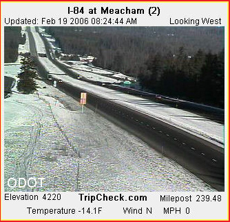
Feb. 18th, the coldest day overall in
the Cold Wave; Meacham records 19
below zero two times (Feb. 18 and Feb. 19). |
40 high
27 low |
21 high
13 below zero |
17 high
19 below zero |
|
Feb. 19th, this is the day the arctic
air dies out and winds calm; the cold wave is on its way out.
Horse Ridge east of Bend records 20 below, coldest anywhere during
this Cold Wave. |
47 high
23 low |
21 high
15 below zero |
21 high
15 below zero |
|
Feb. 20th, the icy winds have ended
and in the Willamette Valley the calm air creates the coldest
morning low temperatures of the entire Cold Wave. |
38 high temp.
22 low temp, with average temp. for the
day of 30, the lowest of the entire cold Wave! |
27 high temp
12 below zero |
31 high temp
0 low temp |
|
Feb. 21, the whole State has warmed
up and the Cold Wave hits the history books as six days long,
with Portland's lowest having been 22 degrees ABOVE ZERO. |
|
|
|
|
|
|
|
|
 Notes:
In the "good" Old Days, major arctic air invasions would produce
7-14 straight days where Seneca might have average lows
in the minus 30 to minus 40 degree range! Nowadays, minus 15 to
minus 20 figures are about the best that a cold wave seems able
to produce in Oregon..... Is it due to Global Warming? Click
to see some of my discussions of this subject. (image is of
Bend at 4 degrees and looking very, very frigid, with bitter winds
and some blowing snow--- even though 4 degrees is not the truly
arctic temperatures of former years, it can still get pretty wintery
in Bend)
Notes:
In the "good" Old Days, major arctic air invasions would produce
7-14 straight days where Seneca might have average lows
in the minus 30 to minus 40 degree range! Nowadays, minus 15 to
minus 20 figures are about the best that a cold wave seems able
to produce in Oregon..... Is it due to Global Warming? Click
to see some of my discussions of this subject. (image is of
Bend at 4 degrees and looking very, very frigid, with bitter winds
and some blowing snow--- even though 4 degrees is not the truly
arctic temperatures of former years, it can still get pretty wintery
in Bend)