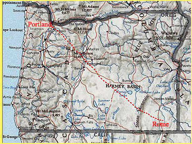
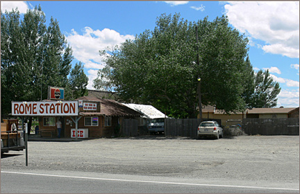
If you are a private plane owner, the Owyhee Country is just a two hour flight, up and over the Cascades, across the long dry plateaus of Eastern Oregon, up and over the nearly 10,000 foot high block of the Steens Mountain, and then down into the dry, broken Owyhee River canyon country, setting your little plane down on the lonely airstrip at Rome, 340 air miles later...Remember to reset your watch, you're now in the Mountain time zone.....The moist, fertile, heavily-populated Willamette Valley is now a distant dream. On your flight, only the first quarter of your journey was over forests-- the rest of your time was over desert landscapes relieved with only scattered juniper trees, and since crossing the Steens, no trees at all, just profoundly arid hills, rimrocks, canyons and dry playas...And NO PEOPLE at all...Rome is hardly more than an unincorporated village with basic services. The airstrip is actually an anomaly, a relic from World War II.* The few basic services include gas, food, a post office (zip 97910), and during the river rafting season, numerous river guides offering spectacular tours of this designated Wild and Scenic River (the Owyhee Wild and Scenic River, 120 miles of which were designated and put into law in 1984).
The term "Owyhee Country" is generally defined as a region in Oregon drained by the 346 mile long Owyhee river and its several forks and tributaries. It's useful to realize that all this region drains to the Pacific Ocean, via the Snake River, and thence into the Columbia River, whereas the vast high plateaus you flew over after leaving Bend, Oregon were part of the Basin and Range Province, where the streams go nowhere except into oblivion on the numerous dry playas and sandy bottomlands. .. Meanwhile, the term "Southeastern Oregon" is a somewhat loose term that includes the Owyhee, but is much larger than the Owyhee region. ....
What's out there
in the Owyhee Country? How big is it, really?
How many people live there? (only 10,000 people in an area as
large as the entire Willamette Valley).
compare populations, an estimated 2 million vs. 10,000.
The population of only one of the Willamette Valley's smallest
cities would populate the entire Owyhee region (eg. the populaton
of just Woodburn, Oregon would DOUBLE the population of the entire
Owyhee region)....
* the airstrip is a relic of World War II, built by the Army Air Force as an emergency landing strip, and turned over to the State a few years after the War. It's elevation is 4,050 ft. and it's a 6,000 ft. runway.
Draw a line around the Oregon part of the Owyhee region, and walk the circumference, it is about 350 miles. Draw the same line around the Willamette Valley, and it's about the same distance! The Owyhee is an enormous, empty and very forgotten part of Oregon.
A "WSA" (Wilderness Study Area) is an area of special interest, meeting criteria for possessing "Wilderness qualities." They designated by Congree and managed by the BLM (federal Bureau of Land Management). There are 15 in and around the Owyhee Canyon, and additional ones just over the border with Idaho. In fact, there is a brand-new 267,000 acre Wilderness just over the border, named the Owyhee River Wilderness . It was established, along with several others in SE Idaho, by the 2009 Omnibus Public Lands Management Act signed by President Obama.
The Sierra Club in the Portland area has been very active for years on behalf of the Owyhee area. Their High Desert committee would be the contact point. Their main office is in SE Portland at 18th and Ankeny.
Points of interest include: several hot springs, such as Snively and others near Leslie Gulch and Three Forks.... Also look for The Honeycombs, Leslie Gulch, Jordan Craters, Three Forks, Anderson Crossing, Louse Canyon, and don't forget the famed the Pillars of Rome (picture from Wikipedia Commons). Oregon Canyon , Battle Mountain, Rattlesnake Canyon, Cedar Mountain, Palomino Hills, Fort McDermitt Indian Reservation, Lake Owyhee State Park.
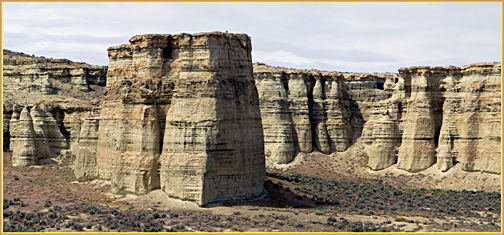 about five miles
long
about five miles
longHistorical Origins-- the origin of the name "Owyhee" is an older spelling of the modern "Hawaii." It dates back to the early 1800s, when some "Sandwich Islanders" were part of an exploration party captained by the famous Donald MacKenzie. Two or three of them were sent to trap on the Owyhee River, and were never seen alive again, the fairly well documented explanation being that they were killed by Snake Indians.
Unique Climate of the Owyhee Canyonlands. The climate of the Owyhee is radically different than the typical tourist image of lush, green, mild Oregon! Even the seasons are reversed from that expected by the average Oregonian; in the Owyhee, winter is not the rainiest season, that comes in May and June, as is typical in much of the Inter-Mountain West. However, do not make the mistake of visualizing RAIN in the Western Oregon sense of the term! Rome pulls down only a meagar 8 inches of rain per year, and achieves only 41 days per year with measurable precipitation. Even the big High Desert city of Bend has nearly twice as many days of precipitation (75), and Portland suffers under 151 days of precipitation, nearly half of the days per year having some precipitation. DRY AND SUNNY is a quite typical weather forecast all year in Owyhee country. Compared with Bend, Rome's winters have much less snowfall, and it is seldom on the ground for very long. Temperature-wise, Bend and Rome are at nearly the same elevations, so I will compare them---Rome is slightly colder than Bend in the winter, but much warmer in the summer (average daily high in July 92.6 vs. only 81.4 at Bend). Although wintertime extreme cold can come to Rome on arctic air invasions, these tend to be less severe than in the High Desert areas like Burns, and especially less severe than in Northeastern Oregon, eg. Baker or Enterprise. There are climatic reasons why the Desert Horned Toad is native to the Owyhee and rare or absent elsewhere in Eastern Oregon.
One recommended reading resource: "Unobscured Horizons, Untravelled Trails, Hiking the Oregon High Desert" by Bruce Hayse, 120 pgs. 6.5 x 8 inches, softbound. Olive Press, Portland, Oregon, 1979. "Published with assistance fo the Oregon Chapter and Columbia Group of the Sierra Club."