Three Maps of Wild Oregon and one Map of North America before the White Man came.

The cool, rainy Oregon Coastal ZoneThis strip contains nearly all of Oregon's population within the Willamette Valley,
Portland, Rogue Valley, and areas around Redmond,Bend and Klamath Falls. It also contains the vast forests and snow capped
volcanoes of the Cascade RangeThis strip encompasses the vast empty Oregon High Desert and Ochoco Mountain uplands,
as well as a very empty but productive wheat-producing zone in the north part of the map, eg. Sherman County.This section contains Oregon's coldest town (Seneca), and the magnificent Steens
Mountain, and in the north the fertile zone around Pendleton and UmatillaThe remote eastern edge of Oregon has such wonders as the Wallowa Mountains, Hells Canyon,
remote Halfway, fertile Ontario, and, in more southerly section, Basque country near Danner and Lesley Gulch

Map to Guide Your Tour of Oregon

Hint:. hover your mouse cursor over the five sections of the map above to obtain detailed zone descriptions!. For a much larger version of this map, please go to page bottom.

Driving Distances:
 Florence on central Coast to Ontario near Idaho = 388 miles
 Astoria on north Coast to Baker City in far NE = 396 miles
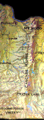
 Portland to the Oregon-California border = 310 miles
 Most Extreme--- Oregon's longest and most extreme Road Trip on major, paved routes is from wet, wet Astoria to fabulously dry McDermitt, on the Nevada border east of Steens Mountain = 532 miles

Link to a map showing the magnetic declination compensations needed for your part of the USA, including Alaska


BBelow is a map of the Historic ranges of the Native American Tribes of Oregon


Please click the link below to view a good State highway map and the Oregon Dept. of Transportation's truly excellent network of live highways cameras, some with a current temperature display! Many other States do not have such a resource, and Oregonians can witness their tax dollars well-spent in these cameras.

Live State Highway Cameras.


Return to OregonPhotos main index

Return to Oregon Climate page