Our Indian Trail Springs
site in the Ochoco Mtns lies 135 air miles NW of the Steens Mountain
area. This is usually a telling difference in terms of
avoiding the Summer Monsoon season that often holds the Steens
under a gloomy sway during the summer months (see satellite image
at page bottom).... But the occasional unlucky year will see a
strong monsoonal effect move well north and west of its usual
home (which is over Nevada and extreme southeastern Oregon)...
That is what happened for about one week in 2004, unfortunately,
right in the middle of the annual OSP--- Hallmarks of a monsoonal
pattern include temperatures exceptionally warm/hot for the elevation,
with humidity 10-30 % higher than usual, showers, lightning, and
lack of any real clearing at night. Also noted are exceptionally
high nightime temps, such as a LOW of 68 degrees on Friday night/Saturday
morning, the highest nightly low this observer has ever seen at
5,000 ft. high Indian Trail Springs! For the first time in 12
years at this site, I was unable to sleep in my sleeping bag due
to the heat!
Note: although Western Oregon appears nice and clear, in
fact the skies all over the NW Willamette Valley were quite smoky,
and nightime astronomy pretty poor due to it.
Regional Temperatures reflected some bizarre patterns as we drove
from the OSP site in the Ochoco Mtns back to Portland (in the
upper Willamette Valley). Our drive back to Portland was on Sunday
in the mid to late afternoon. We encountered 96 degree heat in
Warm Springs at 1500 ft., but when we reached Government Camp
on Mt. Hood (3900 ft) the heat was gone and it was a mild 74 degrees.....
Earlier that day, when we'd left OSP around 1pm, there had been
a hot, intense sun, with an 86 degree air temperature, and a dry
38% humidity. The OSP morning low had been 59, cooler by nearly
ten degrees from the night before!
As we drove back toward Portland, there was atmospheric smokiness
everywhere, both east and west of the Cascades; at the 4000 ft.
crest of the Cascades it was somewhat less smoky. Even at 4000
ft. one could tell that the atmosphere was definitely not very
transparent.
The Day after OSP was Monday. At noon, from near Molalla, there
was a very impressive wall of thunderheads visible far to the
east, beyond the crest of the Cascade Range. But around Molalla
itself, it was clear, although quite smoky/hazy, with mild breezes,
about 77 degrees, but feeling hotter than that due to unusually
humid condtions (the high humidity was one effect of the monsoonal
air leaking over the Cascades from Eastern Oregon).....
Noon conditions around the State on Monday included:
Newport, on the Oregon Coast, 63 degrees, fair,
winds NW at 9 mph (Sunday's high had been 68, with very mixed
weather, ranging from sun to lots of fog, clouds, even dizzle
and light rain)
Portland, 73, mostly sunny, winds NW at 6 mph, 59 % humidity.
Sunday's high had been 84, on a day that ranged from overcast
to mostly cldy to partly cloudy! Due to the humidity, Sunday had
felt rather uncomfortable all over the Willamette Valley.
Salem, 74, sunny. Sunday's high had been 85, but except
for a couple hours of clouds in early morning, the day had been
"fair." (although smoky and humid)
Medford, 80, sunny, winds W at 5 mph, 36% humidity, quite
high for this station. (high Sunday had been 93)
The Dalles, 81, mostly sunny, winds NW 22mph, gusty to
33 mph, 50% humidity (very high humidity for east of the Cascades
in mid-summer!); pressure 29.93 (pressure at Astoria was higher,
30.09, thus the west winds at The Dalles)
Pasco/Tri-Cities, 86, Sunday's high had been a blistering
103 under fair skies. Lucky for us that we don't hold OSP at this
often clear but hellishly hot location!
Hermiston, 88, partly sunny, winds W at 10mph, 40% humidity.
(high Sunday had been 99)
Redmond, 82, mostly sunny, winds variable and 5 mph, 35%
humidity (quite high for this very deserty station), 30.07 barometer--
high Sunday had been 95 with fair skies, but then t-storms occurred
the evening and in the early morning hours, which had brought
light rain-- definitely monsoonal patterns!)
John Day, 77, overcast, 30.12 winds NE 7 (Sunday had seen
93 degrees--- Ontario had had a high of 96 and fair Sunday--
it was east of most of the thunderstorm zone)
Govt. Camp at 4000 ft. on Mt. Hood, 72 degrees, partly
sunny, winds west at 12 mph (Sunday high unknown, est. 75 to 76).
Santiam Pass at 4800 ft. near Sisters, 79 deg, hazy sun,
winds west at 12 mph.
Willamette Pass, 5100 ft., 74 deg, no wind, probably sunny
from the looks of the road cam.
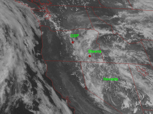
Below are two more typical summer thunderstorm pattern over Oregon. Generally, the more severe thunderstorms and rain stay to the south and southeast of our Indian Trail Springs site...
In the first satellite image it is late afternoon in mid-summer, and
one can easily note some thundercloud build-up over Eastern Oregon,
but most of it stays a bit south and east of our site.....This
type of pattern has the BIG advantage for astronomers that the
clouds will dissipate nicely after dark, leaving clear skies for
observing all night long! This first image documents typical mid-summer
afternoon cumulus/thundercloud build-up in the usual places: over
the Southern Cascades, the Paulina Mountains, the Wallowas, a
bit over the Ochoco Mtns, and a troublesome wad right over Steens Mountain! The serious cloud build-ups
begin at the Oregon-Nevada border. 
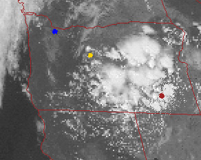
In the second image, taken in August in the early afternoon, one will note a more threatening pattern. It's a very extensive and serious thundercloud build-up over Eastern Oregon oozing into Central Oregon. The Steens will be horrible today and tonight. The OSP site (yellow dot) is on the edge of it, and may or may not get blasted, and has a much better chance than the Steens of clearing some during the night and allowing some astronomy. Meanwhile, ironically, it's a good time for astronomers in the Willamette Valley, Portland is the blue dot. Further north, the Puget Sound area and Seattle are cloudy and cool with light rains.