 below
belowA Big Island resident who is a very keen weather observer has contributed this section on the weather and climate of the Big Island, Mauna Kea and Hilo:
He writes, "Yes I do like the study of weather and have taken some upper division courses in planetary atmospheres and atmospheric formation."
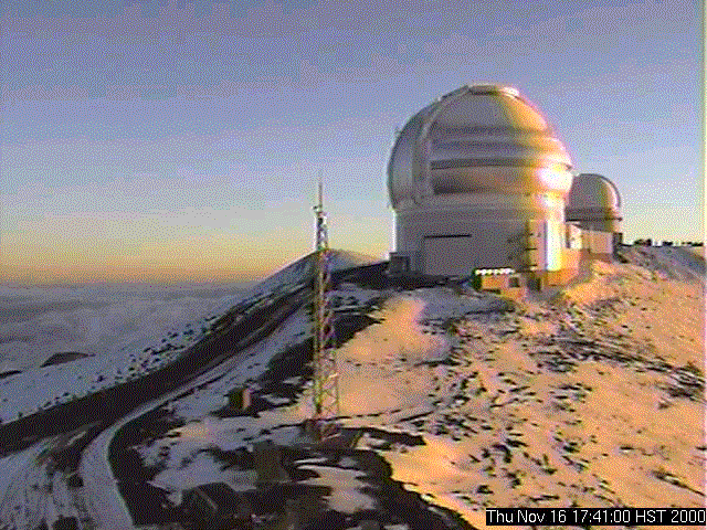
"We got 2 inches of snow on Mauna Kea last night, and it was a really beautiful sight this morning (see image below). This was the first substantive snow fall of the season. Mauna Kea Weather Center is found at http://hokukea.soest.hawaii.edu/
Clouds below
"When I was working at the Air Force Observatory on Haleakala, Maui, we got 12 inches of snow in Jan 1990." (Note: Haleakala Crater is about 10,000 feet high, lying some 3,500 feet lower than the summit of Mauna Kea pictured above)
"On the Big Island, we lose our trade winds in the summer with their return around mid September. Summer is famous for Kona winds which emanate from the South, and causes some of our hots days starting around late July early August. But, what we call hot is not really that hot. I believe the all time record high temp in Honolulu is only 94 degrees. We've tied that record a few times over the past 15 years."
"In the daytime the Inversion layer usually lies around 6,000-6500 feet here in the islands and at times rises to 7,500-8,000 feet. It was around 6,000-6200 feet today (near Hilo, HI). I use Mt Hualalai, a nearby 8275 ft peak North East of Kona as a quick visual reference. From what I can tell, the inversion layer rarely if every drops to 5000 feet." (in the picture above, you are looking DOWN upon the tops of the clouds, which is the day-in, day-out experience of being well above the inversion layer)
Note: Hilo is infamous for its high amounts of rain and clouds: Park writes, "This is what I was taught about Hilo's night-time rain fall pattern. That much of our night -time rain is caused by a downward flowing cool air mass which starts before sunset from the Eastern slopes of Mauna Kea as the land mass succumbs to shadows and quickly cools down in temperature. The cooler denser air mass descends down upon Hilo and displaces the warm moist air forcing it up in elevation and condensing. I believe the cycle is an adiabatic event."
Hilo soaked! (Referring to winter 2000-2001): "Yes, the winter weather has returned to Hilo, but with a vengeance. Hilo got a record 29 inches of rain in only 24 hours eight days ago (Nov. 9, 2000). It caused a lot of havoc in our town and on this Island (Hawaii). The Kau District just south of Volcano Park got 36.7 inches, which was an All-time record for the Big Island. I'm being honest with you when I say I didn't even know it was possible for that much rain to fall in such a short time."
"As a trivial note, it's been claimed that the Big Island has more micro climates then anywhere else in the world. One for every 1500 feet in elevation."
"As for the wettest places. Reports from the Old Timer's in the O'okala region of the big island of Hawaii claim to have recieved up to 800 inches of rain in a single year in the late 40's early 50's, but those numbers are still unoffical since that was prior to regimented record keeping. My friend's family have had a ranch there for over 3 generations."
-- Park McGraw